
Hoima topographic map
Interactive map
Click on the map to display elevation.
About this map
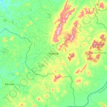
Name: Hoima topographic map, elevation, terrain.
Location: Hoima, Western Region, Uganda (1.27098 31.19251 1.59098 31.51251)
Average elevation: 1,132 m
Minimum elevation: 1,001 m
Maximum elevation: 1,463 m
Other topographic maps
Click on a map to view its topography, its elevation and its terrain.
Lake Albert
Lake Albert, Hoima, Western Region, Uganda
Average elevation: 1,076 m
Mukarange;Block 84
Uganda > Hoima > Mukarange;Block 84
Mukarange;Block 84, Hoima, Western Region, Uganda
Average elevation: 1,130 m