Geolocate

Weston topographic map

Click on the map to display elevation.

About this map

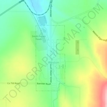
Name: Weston topographic map, elevation, terrain.

Location: Weston, Umatilla County, Oregon, 97886, United States (45.80654 -118.43067 45.82537 -118.41994)

Average elevation: 595 m

Minimum elevation: 530 m

Maximum elevation: 701 m

Other topographic maps

Click on a map to view its topography, its elevation and its terrain.

Myrick

United States > Oregon > Umatilla County

Average elevation: 535 m

Nolin

United States > Oregon > Umatilla County

Average elevation: 295 m

Meacham

United States > Oregon > Umatilla County

Average elevation: 1,166 m

Wallula Gap

United States > Oregon > Umatilla County

Average elevation: 313 m

Gear up for your next adventure:

🗺️Topographic Maps - Detailed maps for hiking and navigation
🛌Compact Down Sleeping Bags - Warmth without the bulk, ideal for backcountry camping
🥾Hiking Boots - Durable hiking boots for trails and rough terrain
🧺Waterproof Dry Sacks - Organize your pack and keep electronics safe from rain and river crossings
🎽Base Layers - Thermal base layers

As an Amazon Associate, this site earns from qualifying purchases at no extra cost to you.