Geolocate

Meacham topographic map

Click on the map to display elevation.

About this map

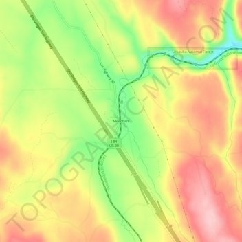
Name: Meacham topographic map, elevation, terrain.

Location: Meacham, Umatilla County, Oregon, 97859, United States (45.48649 -118.44113 45.52649 -118.40113)

Average elevation: 1,166 m

Minimum elevation: 1,065 m

Maximum elevation: 1,246 m

Other topographic maps

Click on a map to view its topography, its elevation and its terrain.

Pendleton

United States > Oregon > Umatilla County

Average elevation: 402 m

Pendleton

United States > Oregon > Umatilla County

Average elevation: 402 m

Ukiah

United States > Oregon > Umatilla County

Average elevation: 1,030 m

Pendleton

United States > Oregon > Umatilla County

Average elevation: 402 m

Echo

United States > Oregon > Umatilla County

Average elevation: 212 m

Hermiston

United States > Oregon > Umatilla County

Average elevation: 160 m

Wallula Gap

United States > Oregon > Umatilla County

Average elevation: 313 m

Umatilla

United States > Oregon > Umatilla County

Average elevation: 142 m

Weston

United States > Oregon > Umatilla County

Average elevation: 595 m

Gear up for your next adventure:

🎧Bluetooth Outdoor Earbuds - Listen to navigation cues or podcasts during long solo treks
🎒Ultralight Backpacks - Lightweight packs for long hikes
🔦Headlamps - Hands-free lighting for hiking
🧥Insulated Down Jackets - High warmth-to-weight ratio for cold nights in the high country
🧰Survival Kits - Essential survival gear

As an Amazon Associate, this site earns from qualifying purchases at no extra cost to you.