
Jiangsu topographic map
Interactive map
Click on the map to display elevation.
About this map
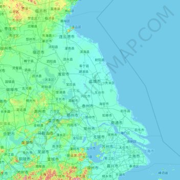
Name: Jiangsu topographic map, elevation, terrain.
Location: Jiangsu, China (30.76033 116.35520 35.16667 122.38666)
Average elevation: 24 m
Minimum elevation: -3 m
Maximum elevation: 1,144 m
Jiangsu is flat, with plains covering 68 percent of its total area (water covers another 18 percent). Most of the province stands not more than 50 meters (160 ft) above sea level. Jiangsu also has a well-developed irrigation system, which earned it (especially the southern half) the moniker of traditional Chinese: 水鄕; simplified Chinese: 水乡 (shuǐxiāng "land of water"). The southern city of Suzhou has so many canals that it has been dubbed "Venice of the East" or the "Venice of the Orient." The Grand Canal of China cuts through Jiangsu from north to south, crossing all the east–west river systems. Jiangsu also borders the Yellow Sea. The Yangtze River, the longest river of China, cuts through the province in the south and reaches the East China Sea, which divides the region into two parts: more urban, prosperous south and more poorer, rural north, and these two parts has a tense division. Mount Huaguo, near the city of Lianyungang, is the highest point in Jiangsu, at an altitude of 625 meters (2,051 ft) above sea level. Large lakes in Jiangsu include Lake Tai (the largest), Lake Hongze, Lake Gaoyou, Lake Luoma, and Lake Yangcheng.
Other topographic maps
Click on a map to view its topography, its elevation and its terrain.
Xingtan
China > Guangdong Province > Shunde District
Xingtan, Shunde District, Foshan, Guangdong Province, China
Average elevation: 4 m
Baiyu
China > Sichuan > Baiyü County > Jianshe
Baiyu, Jianshe, Baiyü County, Kardze, Sichuan, 627100, China
Average elevation: 3,959 m
Gaozhou City
China > Guangdong Province > Maoming City
Gaozhou City, Maoming City, Guangdong Province, 525200, China
Average elevation: 187 m
卡瓦格博观景台
China > Tibet > Zogang County > Pütog
卡瓦格博观景台, 甲应路, Pütog, Zogang County, Chamdo City, Nyingchi Prefecture, Tibet, China
Average elevation: 4,323 m
Tekes
China > Xinjiang > Tekes County
Tekes, Tekes County, Ili, Xinjiang, China
Average elevation: 1,587 m
Linkou County
Linkou County, Mudanjiang City, Heilongjiang, China
Average elevation: 432 m
Chini
China > Guangdong Province > Huadu District
Chini, Huadu District, Guangzhou City, Guangdong Province, China
Average elevation: 30 m
Macau
China > Macau > São Lourenço
Macau, São Lourenço, Municipality of Macau, Macau, 519020, China
Average elevation: 17 m
Chengguan District
Chengguan District, Lhasa, Tibet, 850000, China
Average elevation: 4,325 m
Nanguan District
China > Jilin > Changchun City
Nanguan District, Changchun City, Jilin, 130000, China
Average elevation: 241 m
Kashgar Prefecture
China > Xinjiang > Kashgar City
Kashgar Prefecture, Kashgar City, Kashgar Prefecture, Xinjiang, 844000, China
Average elevation: 2,275 m
Danba
China > Sichuan > Danba County
Danba, Danba County, Kardze Tibetan Autonomous Prefecture, Sichuan, China
Average elevation: 3,257 m
Chongchuan District
Chongchuan District, Nantong, Jiangsu, 226000, China
Average elevation: 3 m
Guzai
China > Guangxi > Du'an Yao Autonomous County
Guzai, Du'an Yao Autonomous County, Hechi, Guangxi, China
Average elevation: 152 m
Goujie
China > Yunnan > Yiliang County
Goujie, Yiliang County, Yunnan, China
Average elevation: 1,810 m
Gaohong
China > Zhejiang > Lin'an District
Gaohong, Lin'an District, Hangzhou City, Zhejiang, China
Average elevation: 282 m
Sha
China > Fujian > Fenggang Subdistrict
Sha, Fenggang Subdistrict, Shaxian District, Sanming City, Fujian, 365500, China
Average elevation: 397 m
Northeast China
China > Heilongjiang > Harbin
Northeast China, Harbin, Heilongjiang, China
Average elevation: 244 m
Keli
China > Fujian > Datian County
Keli, Datian County, Sanming City, Fujian, China
Average elevation: 721 m
Shigatse
China > Tibet > Chengdong Subdistrict
Shigatse, Chengdong Subdistrict, Samzhubzê District, Shigatse Prefecture, Tibet, China
Average elevation: 4,055 m
Qingshui River
China > Hebei > Zhangjiakou City > 闫家屯村
Qingshui River, 闫家屯村, Zhangjiakou City, Hebei, 075000, China
Average elevation: 781 m