
Quarten topographic map
Interactive map
Click on the map to display elevation.
About this map
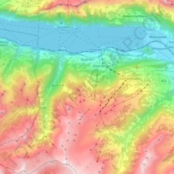
Name: Quarten topographic map, elevation, terrain.
Location: Quarten, Wahlkreis Sarganserland, St. Gallen, Schweiz (47.02592 9.13806 47.14871 9.30368)
Average elevation: 1,283 m
Minimum elevation: 416 m
Maximum elevation: 2,490 m
Other topographic maps
Click on a map to view its topography, its elevation and its terrain.
The Crack
Schweiz > St. Gallen > Wahlkreis Sarganserland > Walenstadtberg
The Crack, Hinterbüls, Walenstadtberg, Walenstadt, Wahlkreis Sarganserland, St. Gallen, 8881, Schweiz
Average elevation: 1,253 m
Mels
Schweiz > St. Gallen > Wahlkreis Sarganserland
Mels, Wahlkreis Sarganserland, St. Gallen, Schweiz
Average elevation: 1,317 m
Portels
Schweiz > St. Gallen > Wahlkreis Sarganserland > Flums
Portels, Flums, Wahlkreis Sarganserland, St. Gallen, 8895, Schweiz
Average elevation: 816 m
Sargans
Schweiz > St. Gallen > Wahlkreis Sarganserland
Sargans, Wahlkreis Sarganserland, St. Gallen, 7320, Schweiz
Average elevation: 707 m
Bad Ragaz
Schweiz > St. Gallen > Wahlkreis Sarganserland
Bad Ragaz, Wahlkreis Sarganserland, St. Gallen, 7310, Schweiz
Average elevation: 951 m