
Mels topographic map
Interactive map
Click on the map to display elevation.
About this map
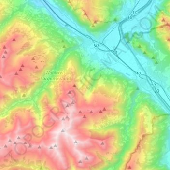
Name: Mels topographic map, elevation, terrain.
Location: Mels, Wahlkreis Sarganserland, St. Gallen, Schweiz (46.92702 9.23628 47.08138 9.48523)
Average elevation: 1,317 m
Minimum elevation: 442 m
Maximum elevation: 2,801 m
Der Turnverein Mels ist mehrfacher Schweizermeister in den Disziplinen Barren- und Bodenturnen. 1993 wurde die humoristische Akrobatiktruppe D’Holmikers gegründet, die seither an unzähligen internationalen Shows teilgenommen hat. Als Höhepunkt gilt der Gewinn des «bronzenen Clowns» anlässlich des 41. internationalen Zirkusfestivals von Monte Carlo.
Other topographic maps
Click on a map to view its topography, its elevation and its terrain.
The Crack
Schweiz > St. Gallen > Wahlkreis Sarganserland > Walenstadtberg
The Crack, Hinterbüls, Walenstadtberg, Walenstadt, Wahlkreis Sarganserland, St. Gallen, 8881, Schweiz
Average elevation: 1,253 m
Portels
Schweiz > St. Gallen > Wahlkreis Sarganserland > Flums
Portels, Flums, Wahlkreis Sarganserland, St. Gallen, 8895, Schweiz
Average elevation: 816 m
Quarten
Schweiz > St. Gallen > Wahlkreis Sarganserland
Quarten, Wahlkreis Sarganserland, St. Gallen, Schweiz
Average elevation: 1,283 m
Sargans
Schweiz > St. Gallen > Wahlkreis Sarganserland
Sargans, Wahlkreis Sarganserland, St. Gallen, 7320, Schweiz
Average elevation: 707 m
Bad Ragaz
Schweiz > St. Gallen > Wahlkreis Sarganserland
Bad Ragaz, Wahlkreis Sarganserland, St. Gallen, 7310, Schweiz
Average elevation: 951 m