
Géromont topographic map
Interactive map
Click on the map to display elevation.
About this map
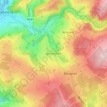
Name: Géromont topographic map, elevation, terrain.
Location: Géromont, Malmedy, Verviers, Liège, Wallonie, 4960, Belgique (50.39104 6.03595 50.43104 6.07595)
Average elevation: 462 m
Minimum elevation: 334 m
Maximum elevation: 568 m
Other topographic maps
Click on a map to view its topography, its elevation and its terrain.
Ligneuville
Belgique > Liège > Verviers > Malmedy
Ligneuville, Malmedy, Verviers, Liège, Wallonie, 4960, Belgique
Average elevation: 437 m
Lamonriville
Belgique > Liège > Verviers > Malmedy
Lamonriville, Malmedy, Verviers, Liège, Wallonie, 4960, Belgique
Average elevation: 427 m