
Jefferson County topographic map
Interactive map
Click on the map to display elevation.
About this map
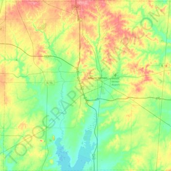
Name: Jefferson County topographic map, elevation, terrain.
Location: Jefferson County, Illinois, VS (38.12500 -89.15141 38.47692 -88.70181)
Average elevation: 150 m
Minimum elevation: 122 m
Maximum elevation: 194 m
Other topographic maps
Click on a map to view its topography, its elevation and its terrain.
Carpentersville
VS > Illinois > Carpentersville
Carpentersville, Kane County, Illinois, VS
Average elevation: 253 m
Mount Vernon
VS > Illinois > Mount Vernon
Mount Vernon, Jefferson County, Illinois, VS
Average elevation: 147 m