
Carroll County topographic map
Interactive map
Click on the map to display elevation.
About this map
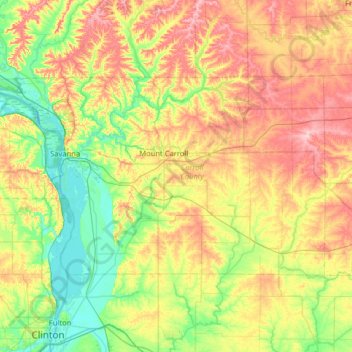
Name: Carroll County topographic map, elevation, terrain.
Location: Carroll County, Illinois, VS (41.93028 -90.32295 42.19832 -89.68557)
Average elevation: 235 m
Minimum elevation: 175 m
Maximum elevation: 325 m
Other topographic maps
Click on a map to view its topography, its elevation and its terrain.
Carpentersville
VS > Illinois > Carpentersville
Carpentersville, Kane County, Illinois, VS
Average elevation: 253 m
Mount Vernon
VS > Illinois > Mount Vernon
Mount Vernon, Jefferson County, Illinois, VS
Average elevation: 147 m