
Exeter topographic map
Interactive map
Click on the map to display elevation.
About this map
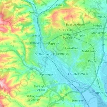
Name: Exeter topographic map, elevation, terrain.
Location: Exeter, Devon, England, United Kingdom (50.67318 -3.57020 50.76147 -3.45116)
Average elevation: 56 m
Minimum elevation: -3 m
Maximum elevation: 218 m
The city of Exeter was established on the eastern bank of the River Exe on a ridge of land backed by a steep hill. It is at this point that the Exe, having just been joined by the River Creedy, opens onto a wide flood plain and estuary which results in quite common flooding. Historically this was the lowest bridging point of the River Exe which was tidal and navigable up to the city until the construction of weirs later in its history. This combined with the easily defensible higher ground of the ridge made the current location of the city a natural choice for settlement and trade. In George Oliver's The History of the City of Exeter, it is noted that the most likely reasons for the original settling of what would become modern Exeter was the "fertility of the surrounding countryside" and the area's "beautiful and commanding elevation [and] its rapid and navigable river". Its woodland would also have been ideal for natural resources and hunting.
Other topographic maps
Click on a map to view its topography, its elevation and its terrain.
Dawlish
United Kingdom > England > Devon > Teignbridge
Dawlish, Teignbridge, Devon, England, United Kingdom
Average elevation: 44 m
Tavistock
United Kingdom > England > Devon > West Devon
Tavistock, West Devon, Devon, England, United Kingdom
Average elevation: 139 m
Sandford
United Kingdom > England > Devon > Mid Devon
Sandford, Mid Devon, Devon, England, United Kingdom
Average elevation: 114 m
Chivelstone
United Kingdom > England > Devon > South Hams
Chivelstone, South Hams, Devon, England, United Kingdom
Average elevation: 58 m
Broadhembury
United Kingdom > England > Devon > East Devon > Broadhembury
Broadhembury, East Devon, Devon, England, United Kingdom
Average elevation: 151 m
Orcombe Point
United Kingdom > England > Devon > East Devon > Exmouth
Orcombe Point, Exmouth, East Devon, Devon, England, EX8 2DH, United Kingdom
Average elevation: 16 m
Chagford
United Kingdom > England > Devon > West Devon
Chagford, West Devon, Devon, England, United Kingdom
Average elevation: 309 m
Northam
United Kingdom > England > Devon > Torridge District
Northam, Torridge District, Devon, England, United Kingdom
Average elevation: 17 m
Lake
United Kingdom > England > Devon > North Devon > Lake
Lake, Tawstock, North Devon, Devon, England, EX31 3HU, United Kingdom
Average elevation: 36 m
Westleigh
United Kingdom > England > Devon > North Devon
Westleigh, North Devon, Devon, England, United Kingdom
Average elevation: 49 m
Thornbury
United Kingdom > England > Devon > Torridge District
Thornbury, Torridge District, Devon, England, United Kingdom
Average elevation: 133 m
Modbury
United Kingdom > England > Devon > South Hams
Modbury, South Hams, Devon, England, United Kingdom
Average elevation: 83 m
Colyton
United Kingdom > England > Devon > East Devon > Colyton
Colyton, East Devon, Devon, South West England, England, United Kingdom
Average elevation: 68 m
Ashburton
United Kingdom > England > Devon > Teignbridge > Ashburton
Ashburton, Teignbridge, Devon, England, United Kingdom
Average elevation: 163 m
Holsworthy
United Kingdom > England > Devon > Torridge District
Holsworthy, Torridge District, Devon, England, United Kingdom
Average elevation: 132 m
Exmouth
United Kingdom > England > Devon > East Devon
Exmouth, East Devon, Devon, England, United Kingdom
Average elevation: 29 m
Ermington
United Kingdom > England > Devon > South Hams
Ermington, South Hams, Devon, England, United Kingdom
Average elevation: 85 m
River Duntz
United Kingdom > England > Devon > Torridge
River Duntz, Frithelstock, Torridge, Devon, South West England, England, EX38 8JT, United Kingdom
Average elevation: 123 m
Woodleigh
United Kingdom > England > Devon > South Hams > Woodleigh
Woodleigh, South Hams, Devon, South West England, England, United Kingdom
Average elevation: 108 m
Clovelly
United Kingdom > England > Devon > Torridge District
Clovelly, Torridge District, Devon, England, United Kingdom
Average elevation: 118 m
Seaton
United Kingdom > England > Devon > East Devon
Seaton, East Devon, Devon, England, United Kingdom
Average elevation: 33 m
Dartmoor National Park
United Kingdom > England > Devon
Dartmoor National Park, Devon, England, United Kingdom
Average elevation: 239 m
Princetown
United Kingdom > England > Devon > West Devon
Princetown, Dartmoor Forest, West Devon, Devon, England, United Kingdom
Average elevation: 415 m
Westward Ho!
United Kingdom > England > Devon > Torridge > Westward Ho!
Westward Ho!, Torridge, Devon, South West England, England, EX39 1HR, United Kingdom
Average elevation: 23 m