Geolocate

Kachin State topographic map

Interactive map

Click on the map to display elevation.

About this map

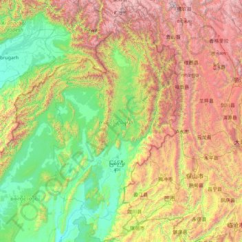
Name: Kachin State topographic map, elevation, terrain.

Location: Kachin State, Myanmar (23.63325 95.80617 28.54784 98.78221)

Average elevation: 1,487 m

Minimum elevation: 82 m

Maximum elevation: 6,429 m

Other topographic maps

Click on a map to view its topography, its elevation and its terrain.

Daw

Myanmar > Tanintharyi Region > Myeik Township > Se Ein Su

Average elevation: 28 m

Bogale

Myanmar > Ayeyarwady > Bogale

Average elevation: 4 m

Nay Pyi Taw

Myanmar > Naypyitaw Union Territory

Average elevation: 133 m

Yangon

Myanmar > Yangon > Yangon

Average elevation: 6 m

Yangon

Myanmar

Average elevation: 158 m

Inn

Myanmar > Sagaing > Inn

Average elevation: 90 m