
Fray Bentos topographic map
Interactive map
Click on the map to display elevation.
About this map
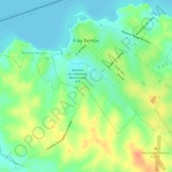
Name: Fray Bentos topographic map, elevation, terrain.
Location: Fray Bentos, Río Negro, 65000, Uruguay (-33.14551 -58.32205 -33.10804 -58.27595)
Average elevation: 18 m
Minimum elevation: 0 m
Maximum elevation: 44 m
Other topographic maps
Click on a map to view its topography, its elevation and its terrain.
San Javier
Uruguay > Río Negro > San Javier
San Javier, Río Negro, 65001, Uruguay
Average elevation: 8 m