Geolocate

Witney topographic map

Click on the map to display elevation.

About this map

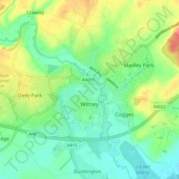
Name: Witney topographic map, elevation, terrain.

Location: Witney, West Oxfordshire, Oxfordshire, England, United Kingdom (51.77526 -1.52759 51.79955 -1.45705)

Average elevation: 92 m

Minimum elevation: 72 m

Maximum elevation: 127 m

Other topographic maps

Click on a map to view its topography, its elevation and its terrain.

Gear up for your next adventure:

🔪Multitools - Compact tools for outdoor use
📱Shockproof Phone Cases - Extra protection for your smartphone against drops on rocky terrain
📷Backpack Camera Clips - Quick access to your camera while keeping your hands free for climbing
🧤Hiking Gloves - Protective gloves for outdoor use
🥾Hiking Gaiters - Leg protection for trails

As an Amazon Associate, this site earns from qualifying purchases at no extra cost to you.