Geolocate

Swinbrook topographic map

Click on the map to display elevation.

About this map

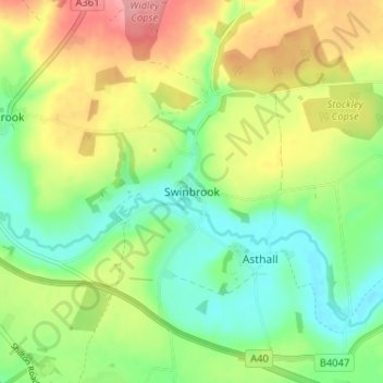
Name: Swinbrook topographic map, elevation, terrain.

Location: Swinbrook, West Oxfordshire, Oxfordshire, England, OX18 4EA, United Kingdom (51.78685 -1.61422 51.82685 -1.57422)

Average elevation: 130 m

Minimum elevation: 89 m

Maximum elevation: 188 m

Other topographic maps

Click on a map to view its topography, its elevation and its terrain.

Kingham

United Kingdom > England > Oxfordshire > West Oxfordshire

Average elevation: 130 m

Lyneham

United Kingdom > England > Oxfordshire > West Oxfordshire

Average elevation: 130 m

Witney

United Kingdom > England > Oxfordshire > West Oxfordshire

Average elevation: 92 m

Hailey

United Kingdom > England > Oxfordshire > West Oxfordshire

Average elevation: 113 m

Gear up for your next adventure:

🎒Hiking Backpacks - Backpacks designed for hiking and trekking
🔪Multitools - Compact tools for outdoor use
🔦Powerful LED Headlamps - Hands-free lighting for night navigation and setting up camp after dark
🔌Fast Charging Adapters - Quickly top up all your gear before heading back into the field
🎒Daypacks - Compact backpacks for short hikes

As an Amazon Associate, this site earns from qualifying purchases at no extra cost to you.