Geolocate

Brookfield topographic map

Click on the map to display elevation.

About this map

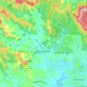
Name: Brookfield topographic map, elevation, terrain.

Location: Brookfield, City of Brisbane, Queensland, 4069, Australia (-27.52146 152.87177 -27.45626 152.93099)

Average elevation: 85 m

Minimum elevation: 6 m

Maximum elevation: 278 m

Queensland trails, hiking, mountain biking, running and outdoor activities

Other topographic maps

Click on a map to view its topography, its elevation and its terrain.

Enoggera Hill

Australia > Queensland > City of Brisbane

Average elevation: 114 m

Tangalooma

Australia > Queensland > City of Brisbane

Average elevation: 41 m

Blunder Creek

Australia > Queensland > City of Brisbane

Average elevation: 26 m

Tangalooma

Australia > Queensland > City of Brisbane

Average elevation: 41 m

Gear up for your next adventure:

🚗Car Camping Gear - Equipment for vehicle camping
🔪Multitools - Compact tools for outdoor use
💡Collapsible Camping Lanterns - Illuminate your base camp or tent for map studying at night
🌬️Windbreaker Jackets - Wind protection jackets
🧥Packable Rain Jackets - Breathable waterproof layers for unpredictable mountain weather

As an Amazon Associate, this site earns from qualifying purchases at no extra cost to you.