
Make a donation
Gear up for your next adventure:
As an Amazon Associate, this site earns from qualifying purchases at no extra cost to you.
Handsacre topographic map
Click on the map to display elevation.
Make a donation
Gear up for your next adventure:
As an Amazon Associate, this site earns from qualifying purchases at no extra cost to you.
About this map
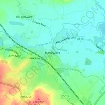
Name: Handsacre topographic map, elevation, terrain.
Average elevation: 77 m
Minimum elevation: 58 m
Maximum elevation: 125 m
Make a donation
Gear up for your next adventure:
As an Amazon Associate, this site earns from qualifying purchases at no extra cost to you.
Other topographic maps
Click on a map to view its topography, its elevation and its terrain.
Make a donation
Gear up for your next adventure:
As an Amazon Associate, this site earns from qualifying purchases at no extra cost to you.
Whittington
United Kingdom > England > Staffordshire > Lichfield > Whittington
Average elevation: 70 m
Chasewater
United Kingdom > England > Staffordshire > Lichfield > Burntwood > Chasetown
Average elevation: 155 m
Make a donation
Gear up for your next adventure:
As an Amazon Associate, this site earns from qualifying purchases at no extra cost to you.
Make a donation
Gear up for your next adventure:
As an Amazon Associate, this site earns from qualifying purchases at no extra cost to you.
Clifton Campville
United Kingdom > England > Staffordshire > Lichfield > Clifton Campville
Average elevation: 77 m
Make a donation
Gear up for your next adventure:
As an Amazon Associate, this site earns from qualifying purchases at no extra cost to you.
Gentleshaw Common
United Kingdom > England > Staffordshire > Lichfield > Longdon
Average elevation: 181 m
Fulfen Wood
United Kingdom > England > Staffordshire > Lichfield > Whittington > Streethay
Average elevation: 69 m
Make a donation
Gear up for your next adventure:
As an Amazon Associate, this site earns from qualifying purchases at no extra cost to you.
Mavesyn Ridware
United Kingdom > England > Staffordshire > Lichfield > Hill Ridware
Average elevation: 81 m