
Make a donation
Gear up for your next adventure:
As an Amazon Associate, this site earns from qualifying purchases at no extra cost to you.
Hints topographic map
Click on the map to display elevation.
Make a donation
Gear up for your next adventure:
As an Amazon Associate, this site earns from qualifying purchases at no extra cost to you.
About this map
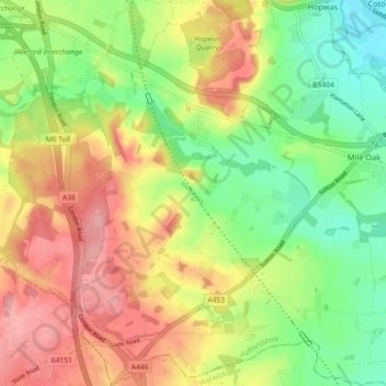
Name: Hints topographic map, elevation, terrain.
Location: Hints, Lichfield, Staffordshire, England, United Kingdom (52.58785 -1.79745 52.64290 -1.75049)
Average elevation: 107 m
Minimum elevation: 53 m
Maximum elevation: 167 m
Make a donation
Gear up for your next adventure:
As an Amazon Associate, this site earns from qualifying purchases at no extra cost to you.
Other topographic maps
Click on a map to view its topography, its elevation and its terrain.
Make a donation
Gear up for your next adventure:
As an Amazon Associate, this site earns from qualifying purchases at no extra cost to you.
Chasewater
United Kingdom > England > Staffordshire > Lichfield > Burntwood > Chasetown
Average elevation: 155 m
Make a donation
Gear up for your next adventure:
As an Amazon Associate, this site earns from qualifying purchases at no extra cost to you.
Make a donation
Gear up for your next adventure:
As an Amazon Associate, this site earns from qualifying purchases at no extra cost to you.
Bullock's End
United Kingdom > England > Staffordshire > Lichfield > Drayton Basset > Bullock's End
Average elevation: 72 m
Gentleshaw Common
United Kingdom > England > Staffordshire > Lichfield > Longdon
Average elevation: 181 m
Make a donation
Gear up for your next adventure:
As an Amazon Associate, this site earns from qualifying purchases at no extra cost to you.
Muckley Corner
United Kingdom > England > Staffordshire > Lichfield > Hammerwich
Average elevation: 120 m
Make a donation
Gear up for your next adventure:
As an Amazon Associate, this site earns from qualifying purchases at no extra cost to you.
Fulfen Wood
United Kingdom > England > Staffordshire > Lichfield > Whittington > Streethay
Average elevation: 69 m
Make a donation
Gear up for your next adventure:
As an Amazon Associate, this site earns from qualifying purchases at no extra cost to you.