
Shahzadpur topographic map
Interactive map
Click on the map to display elevation.
About this map
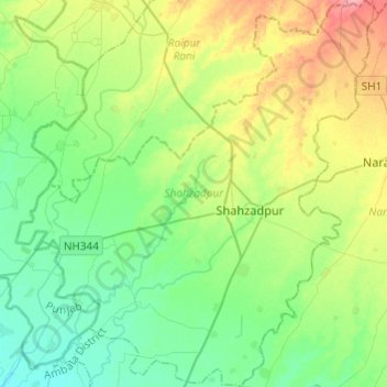
Name: Shahzadpur topographic map, elevation, terrain.
Location: Shahzadpur, Ambala, Haryana, 134202, India (30.35129 76.88680 30.56152 77.11956)
Average elevation: 306 m
Minimum elevation: 278 m
Maximum elevation: 370 m
Other topographic maps
Click on a map to view its topography, its elevation and its terrain.
Para River
India > Haryana > Siwan > KACHI PISOL
Para River, KACHI PISOL, Siwan, Kaithal District, Haryana, 136033, India
Average elevation: 235 m