
Make a donation
Gear up for your next adventure:
As an Amazon Associate, this site earns from qualifying purchases at no extra cost to you.
Saint Louis County topographic map
Click on the map to display elevation.
Make a donation
Gear up for your next adventure:
As an Amazon Associate, this site earns from qualifying purchases at no extra cost to you.
Saint Louis County
The foothills of the Ozark Mountains begin in southwestern St. Louis County, with most of the rest of the county being a fairly level plateau. This western part of the county is the least developed, due to rugged topography. Bluffs along the Mississippi in the south of the county rise about 200–300 feet above the river. A major floodplain area is the Chesterfield Valley, in the western part of the county, along the Missouri River. It was formerly called "Gumbo Flats" after its rich, dark soil; it was submerged by at least ten feet of water during the Great Flood of 1993. The Corps of Engineers constructed a higher levee, and the county has permitted construction in the floodplain.
Make a donation
Gear up for your next adventure:
As an Amazon Associate, this site earns from qualifying purchases at no extra cost to you.
About this map
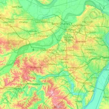
Name: Saint Louis County topographic map, elevation, terrain.
Location: Saint Louis County, Missouri, United States (38.38641 -90.73622 38.89216 -90.11771)
Average elevation: 166 m
Minimum elevation: 113 m
Maximum elevation: 290 m
Make a donation
Gear up for your next adventure:
As an Amazon Associate, this site earns from qualifying purchases at no extra cost to you.
Other topographic maps
Click on a map to view its topography, its elevation and its terrain.
Make a donation
Gear up for your next adventure:
As an Amazon Associate, this site earns from qualifying purchases at no extra cost to you.
Mount Vernon
United States > Missouri > Lawrence County > Mount Vernon > Mount Vernon
Average elevation: 379 m
Make a donation
Gear up for your next adventure:
As an Amazon Associate, this site earns from qualifying purchases at no extra cost to you.
Summers Addition
United States > Missouri > Howell County > West Plains > Summers Addition
Average elevation: 306 m