Geolocate

Basye topographic map

Click on the map to display elevation.

About this map

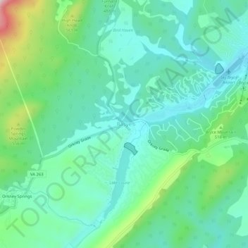
Name: Basye topographic map, elevation, terrain.

Location: Basye, Shenandoah County, Virginia, 22845, United States (38.78706 -78.81224 38.82706 -78.77224)

Average elevation: 462 m

Minimum elevation: 374 m

Maximum elevation: 737 m

Other topographic maps

Click on a map to view its topography, its elevation and its terrain.

Toms Brook

United States > Virginia > Shenandoah County

Average elevation: 232 m

Gear up for your next adventure:

🎒Tactical Waist Packs - Quick access to your compass, phone, and snacks while walking
👖Convertible Hiking Trousers - Zip-off legs to adapt to changing temperatures throughout the day
🚁Camera Drones with GPS - Capture aerial views of the landscape to compare with topo maps
🩹First Aid Kits - Emergency kits for hiking
🧭Compass - Navigation compasses for outdoor exploration

As an Amazon Associate, this site earns from qualifying purchases at no extra cost to you.