
Make a donation
Gear up for your next adventure:
As an Amazon Associate, this site earns from qualifying purchases at no extra cost to you.
Kalbe (Milde) topographic map
Click on the map to display elevation.
Make a donation
Gear up for your next adventure:
As an Amazon Associate, this site earns from qualifying purchases at no extra cost to you.
Kalbe (Milde)
Auf einem 263 Hektar großen Gelände nordöstlich von Calbe an der Milde betrieb die Kriegsmarine von 1943 bis 1945 den Längstwellensender Goliath zur Übermittlung von Befehlen an getauchte U-Boote. Die Antenne dieses Senders, der mit einer Sendeleistung von 1000 Kilowatt der damals stärkste Sender der Welt gewesen sein dürfte, bestand aus einer Schirmantenne, die an 15 abgespannten, geerdeten Gittermasten von 170 Metern Höhe und an drei gegen Erde isolierten Rohrmasten von 204 Meter Höhe aufgehängt war. Nach 1945 diente die Anlage anfangs als Kriegsgefangenenlager, bevor sie 1946 demontiert wurde. Das Fundament von Mast Nummer 8 ist noch erhalten. Nach Demontage wurde der Längstwellensender als erster Sender dieser Art in der Sowjetunion in der Nähe von Nischni Nowgorod in der Siedlung Druschny wieder aufgebaut. Er ist bis heute in Betrieb.
Make a donation
Gear up for your next adventure:
As an Amazon Associate, this site earns from qualifying purchases at no extra cost to you.
About this map
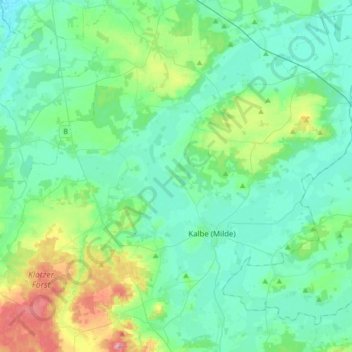
Name: Kalbe (Milde) topographic map, elevation, terrain.
Average elevation: 47 m
Minimum elevation: 22 m
Maximum elevation: 142 m
Make a donation
Gear up for your next adventure:
As an Amazon Associate, this site earns from qualifying purchases at no extra cost to you.
Other topographic maps
Click on a map to view its topography, its elevation and its terrain.
Neu Wernstedt
Deutschland > Sachsen-Anhalt > Altmarkkreis Salzwedel > Kalbe (Milde) > Wernstedt
Average elevation: 49 m
Make a donation
Gear up for your next adventure:
As an Amazon Associate, this site earns from qualifying purchases at no extra cost to you.
Make a donation
Gear up for your next adventure:
As an Amazon Associate, this site earns from qualifying purchases at no extra cost to you.
Groß Wieblitz
Deutschland > Sachsen-Anhalt > Altmarkkreis Salzwedel > Salzwedel
Average elevation: 39 m
Klein Bierstedt
Deutschland > Sachsen-Anhalt > Altmarkkreis Salzwedel > Rohrberg
Average elevation: 52 m
Klein Chüden
Deutschland > Sachsen-Anhalt > Altmarkkreis Salzwedel > Salzwedel
Average elevation: 22 m
Make a donation
Gear up for your next adventure:
As an Amazon Associate, this site earns from qualifying purchases at no extra cost to you.
Deutschhorst
Deutschland > Sachsen-Anhalt > Altmarkkreis Salzwedel > Ellenberg > Deutschhorst
Average elevation: 50 m