
Spring Branch topographic map
Interactive map
Click on the map to display elevation.
About this map
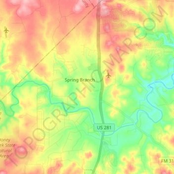
Name: Spring Branch topographic map, elevation, terrain.
Location: Spring Branch, Comal County, Texas, United States (29.82779 -98.44823 29.94236 -98.38294)
Average elevation: 347 m
Minimum elevation: 285 m
Maximum elevation: 415 m
Other topographic maps
Click on a map to view its topography, its elevation and its terrain.
Comal River
United States > Texas > Comal County > New Braunfels > Landa Park Estates
Comal River, Landa Park Estates, New Braunfels, Comal County, Texas, 78130, United States
Average elevation: 206 m
Canyon Springs
United States > Texas > Comal County
Canyon Springs, Comal County, Texas, 79133, United States
Average elevation: 310 m
New Braunfels
United States > Texas > Comal County
New Braunfels, Comal County, Texas, United States
Average elevation: 228 m
Bulverde
United States > Texas > Comal County
Bulverde, Comal County, Texas, United States
Average elevation: 364 m
Canyon Lake
United States > Texas > Comal County
Canyon Lake, Comal County, Texas, 78133, United States
Average elevation: 296 m