
Seungbong-ri topographic map
Interactive map
Click on the map to display elevation.
About this map
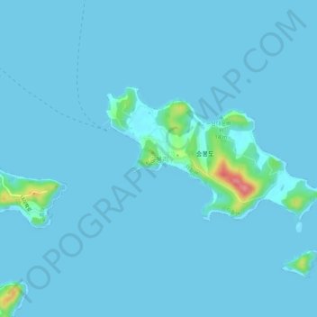
Name: Seungbong-ri topographic map, elevation, terrain.
Location: Seungbong-ri, Incheon, South Korea (37.14612 126.27868 37.18612 126.31868)
Average elevation: 4 m
Minimum elevation: 0 m
Maximum elevation: 90 m
Other topographic maps
Click on a map to view its topography, its elevation and its terrain.
Seobudong Park
Seobudong Park, Bupyeong-dong, Bupyeong-gu, Incheon, South Korea
Average elevation: 30 m
Yeonhui-dong
South Korea > Incheon > Seo-gu > Yeonhui-dong
Yeonhui-dong, Seo-gu, Incheon, South Korea
Average elevation: 22 m
Yeonhui-dong
South Korea > Incheon > Yeonhui-dong
Yeonhui-dong, Incheon, 22734, South Korea
Average elevation: 19 m