Geolocate

Kaneohe topographic map

Click on the map to display elevation.

About this map

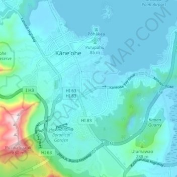
Name: Kaneohe topographic map, elevation, terrain.

Location: Kaneohe, Honolulu County, Hawaii, 96744, United States (21.37929 -157.83038 21.43143 -157.76012)

Average elevation: 105 m

Minimum elevation: -2 m

Maximum elevation: 838 m

Other topographic maps

Click on a map to view its topography, its elevation and its terrain.

Kokokahi

United States > Hawaii > Honolulu County > Kaneohe

Average elevation: 27 m

Keapuka

United States > Hawaii > Honolulu County > Kaneohe

Average elevation: 118 m

Gear up for your next adventure:

Survival Blankets - Emergency thermal blankets
🆘Personal Locator Beacons (PLB) - Satellite emergency beacons for life-saving help in areas with no mobile coverage
🐍Snake Gaiters - Protection against snake bites
📍Handheld GPS - GPS devices for hiking and navigation
🧼Clip-on Hand Sanitizer - Maintain hygiene when water for washing is scarce

As an Amazon Associate, this site earns from qualifying purchases at no extra cost to you.