Geolocate

Mosman Bay topographic map

Click on the map to display elevation.

About this map

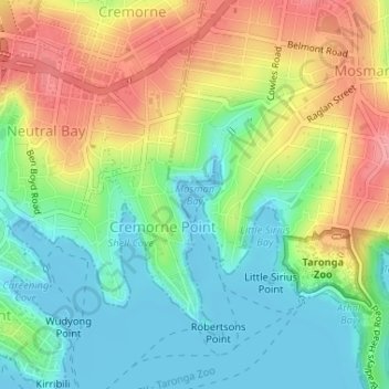
Name: Mosman Bay topographic map, elevation, terrain.

Location: Mosman Bay, Sydney, New South Wales, 2090, Australia (-33.83881 151.23060 -33.83871 151.23070)

Average elevation: 41 m

Minimum elevation: -3 m

Maximum elevation: 99 m

New South Wales trails, hiking, mountain biking, running and outdoor activities

Other topographic maps

Click on a map to view its topography, its elevation and its terrain.

Balgowlah

Australia > New South Wales > Sydney

Average elevation: 40 m

Sydney

Australia > New South Wales > Sydney

Average elevation: 23 m

Penrith

Australia > New South Wales > Sydney > Penrith

Penrith is a city in New South Wales, Australia, located in Greater Western Sydney, 55 kilometres (31 mi) west of the Sydney central business district on the banks of the Nepean River, on the outskirts of the Cumberland Plain. Its elevation is 32 metres (105 ft).

Average elevation: 34 m

Greystanes

Australia > New South Wales > Sydney

Average elevation: 53 m

Thank you for supporting this site ❤️
Make a donation

Gear up for your next adventure:

As an Amazon Associate, this site earns from qualifying purchases at no extra cost to you.

Glenhaven

Australia > New South Wales > Sydney

Average elevation: 132 m

Gables

Australia > New South Wales > Sydney

Average elevation: 47 m

Edmondson Park

Australia > New South Wales > Sydney

Average elevation: 56 m

Pymble

Australia > New South Wales > Sydney

Average elevation: 125 m

North Sydney

Australia > New South Wales > Sydney

Average elevation: 50 m

Castle Hill

Australia > New South Wales > Sydney

Average elevation: 123 m

Heathcote

Australia > New South Wales > Sydney

Average elevation: 148 m

Mount Kuring-Gai

Australia > New South Wales > Sydney

Mount Kuring-gai is located approximately 7 km north of Hornsby. Its neighbouring suburbs are Berowra to the north, and Mount Colah to the south. Surrounded by bushland, it is bordered by Ku-ring-gai Chase National Park on the eastern side and by Berowra Valley Regional Park on the western side. There are…

Average elevation: 133 m

Springwood

Australia > New South Wales > Sydney

Average elevation: 335 m

Mount Druitt

Australia > New South Wales > Sydney

Average elevation: 52 m

Kurrajong Heights

Australia > New South Wales > Sydney

Average elevation: 385 m

Wentworth Falls

Australia > New South Wales > Sydney

Wentworth Falls (postcode: 2782) is a town in the Blue Mountains region of New South Wales, situated approximately 100 kilometres (62 mi) west of the Sydney central business district, and about 8 kilometres (5.0 mi) east of Katoomba, Australia on the Great Western Highway, with a Wentworth Falls railway…

Average elevation: 708 m

Glenorie

Australia > New South Wales > Sydney

Average elevation: 131 m

Hornsby

Australia > New South Wales > Sydney

Average elevation: 160 m

Inner West

Australia > New South Wales > Sydney

Average elevation: 19 m

Millers Point

Australia > New South Wales > Sydney

Average elevation: 14 m

Balmain

Australia > New South Wales > Sydney

Average elevation: 12 m

Upper North Shore

Australia > New South Wales > Sydney

Average elevation: 119 m

Lake Sedgwick

Australia > New South Wales > Sydney

Average elevation: 117 m

Wedderburn

Australia > New South Wales > Sydney

Average elevation: 211 m

Hurstville

Australia > New South Wales > Sydney

Average elevation: 50 m

Macquarie Park

Australia > New South Wales > Sydney

Average elevation: 59 m

Mosman

Australia > New South Wales > Sydney

Average elevation: 29 m

Botany Bay

Australia > New South Wales > Sydney

Average elevation: 8 m

Mount Colah

Australia > New South Wales > Sydney

Mount Colah is 5 km north of Hornsby, the nearest major town centre. It is one of the most northerly suburbs of Sydney and is where the "Welcome to Sydney" sign is located. Mount Colah is the second highest suburb in Sydney by elevation. Considered one of Sydney's leafier suburbs, streets are clustered around…

Average elevation: 152 m

Concord

Australia > New South Wales > Sydney

Average elevation: 12 m

Glebe

Australia > New South Wales > Sydney

Average elevation: 18 m

Kellyville Ridge

Australia > New South Wales > Sydney

Average elevation: 58 m

Rooty Hill

Australia > New South Wales > Sydney

Average elevation: 52 m

Balgowlah Heights

Australia > New South Wales > Sydney

Average elevation: 25 m

Freemans Reach

Australia > New South Wales > Sydney

Average elevation: 22 m

Menangle Park

Australia > New South Wales > Sydney

Average elevation: 92 m

Box Hill

Australia > New South Wales > Sydney

Average elevation: 45 m

Northern Beaches

Australia > New South Wales > Sydney

Average elevation: 67 m

Fairfield Heights

Australia > New South Wales > Sydney

The elevation of this suburb is approximately between 20 and 40 metres (66 and 131 ft) above mean sea level, owing to its name. It has the colloquial nickname in the area of "The Heights".

Average elevation: 24 m

Eastern Suburbs

Australia > New South Wales > Sydney

Average elevation: 13 m

Broken Bay

Australia > New South Wales > Sydney > Brooklyn

Average elevation: 40 m

Airds

Australia > New South Wales > Sydney

Average elevation: 123 m

Wyatt Park

Australia > New South Wales > Sydney

Average elevation: 20 m

Scotland Island

Australia > New South Wales > Sydney

Average elevation: 17 m

Woodford

Australia > New South Wales > Sydney

Woodford is a village in the Blue Mountains in New South Wales, Australia, about 90 kilometres west of Sydney. Its elevation is 609 metres (1,998 ft) above sea level. It is situated on the Great Western Highway and has a railway station (opened in 1868 as Buss's Platform) on the Main Western railway line…

Average elevation: 544 m

Rockdale

Australia > New South Wales > Sydney

Average elevation: 20 m

Wicks Park

Australia > New South Wales > Sydney

Average elevation: 17 m

Bella Vista

Australia > New South Wales > Sydney

Average elevation: 79 m

Waverton

Australia > New South Wales > Sydney

Average elevation: 33 m

Berkshire Park

Australia > New South Wales > Sydney

Average elevation: 27 m

St Leonards

Australia > New South Wales > Sydney

Average elevation: 69 m

Meadowbank Park

Australia > New South Wales > Sydney

Average elevation: 14 m

Denistone West

Australia > New South Wales > Sydney

Average elevation: 55 m

Nelson

Australia > New South Wales > Sydney

Average elevation: 47 m

Beaconsfield

Australia > New South Wales > Sydney

Average elevation: 18 m

Smithfield

Australia > New South Wales > Sydney

Established in 1836, Smithfield was the first major settlement of the Fairfield LGA. The original 1838 summary plan of Smithfield shows the suburb laid out in a grid pattern with most of the streets having the same names as they do today. Its altitude ranges from 21 to 48 m (69 to 157 ft) above sea level.…

Average elevation: 33 m

Beaman Park

Australia > New South Wales > Sydney

Average elevation: 23 m

Browns Waterhole

Australia > New South Wales > Sydney

Average elevation: 73 m

Holroyd

Australia > New South Wales > Sydney

Average elevation: 24 m

Richmond Lowlands

Australia > New South Wales > Sydney

Average elevation: 13 m

Oyster Bay

Australia > New South Wales > Sydney

Average elevation: 25 m

Killarney Heights

Australia > New South Wales > Sydney

Average elevation: 72 m

North Curl Curl

Australia > New South Wales > Sydney

Average elevation: 22 m

Darlinghurst

Australia > New South Wales > Sydney

Average elevation: 38 m

Sans Souci

Australia > New South Wales > Sydney

Average elevation: 4 m

Carlingford

Australia > New South Wales > Sydney

Average elevation: 98 m

Marsfield

Australia > New South Wales > Sydney

Average elevation: 72 m

Gregory Hills

Australia > New South Wales > Sydney

Gregory Hills is a suburb of Sydney in the state of New South Wales, Australia in Camden Council. The suburb was assigned on 1 August 2008. The suburb was named from the topography of the local area and from the original St Gregory's Chapel on the Marist Brothers land.

Average elevation: 109 m

Oran Park

Australia > New South Wales > Sydney

Average elevation: 93 m

Schofields

Australia > New South Wales > Sydney

Average elevation: 32 m

Moorebank

Australia > New South Wales > Sydney

Average elevation: 12 m

Killara

Australia > New South Wales > Sydney

Average elevation: 86 m

Cammeray

Australia > New South Wales > Sydney

Prior to the 1920s, the suburb was known as Suspension Bridge reflecting the now Long Gully Bridge that joined Northbridge to Cammeray. Cammeray was slow to develop mainly due to its steep topography and remoteness from transport.

Average elevation: 66 m

Bringelly

Australia > New South Wales > Sydney

Average elevation: 87 m

Crows Nest

Australia > New South Wales > Sydney

Average elevation: 68 m

Londonderry

Australia > New South Wales > Sydney

Average elevation: 29 m

Annandale

Australia > New South Wales > Sydney

Average elevation: 24 m

Randwick

Australia > New South Wales > Sydney

Average elevation: 44 m

Leichhardt

Australia > New South Wales > Sydney

Average elevation: 22 m

Eastwood

Australia > New South Wales > Sydney

Average elevation: 80 m

North Ryde

Australia > New South Wales > Sydney

Average elevation: 52 m

Rydalmere

Australia > New South Wales > Sydney

Average elevation: 19 m

Liverpool

Australia > New South Wales > Sydney

Average elevation: 14 m

Warragamba

Australia > New South Wales > Sydney

Average elevation: 157 m

Dundas Valley

Australia > New South Wales > Sydney

Average elevation: 73 m

Gladesville

Australia > New South Wales > Sydney

Average elevation: 28 m

Meadowbank

Australia > New South Wales > Sydney

Average elevation: 19 m

Drummoyne

Australia > New South Wales > Sydney

Average elevation: 11 m

North Parramatta

Australia > New South Wales > Sydney

Average elevation: 42 m

Lindfield

Australia > New South Wales > Sydney

Average elevation: 79 m

Kensington

Australia > New South Wales > Sydney

Average elevation: 31 m

Ermington

Australia > New South Wales > Sydney

Average elevation: 32 m

Wolli Creek

Australia > New South Wales > Sydney

Average elevation: 27 m

Lilyfield

Australia > New South Wales > Sydney

Average elevation: 18 m

Wentworth Point

Australia > New South Wales > Sydney

Average elevation: 6 m

Gear up for your next adventure:

🏫Topographic World Globes - 3D physical relief globes to understand global geography
☀️Portable Solar Chargers - High-efficiency panels to hang on your backpack while walking
GPS Watches - GPS watches for outdoor sports
🥾Hiking Shoes - Lightweight hiking shoes for day hikes
🧰Survival Kits - Essential survival gear

As an Amazon Associate, this site earns from qualifying purchases at no extra cost to you.