
Holmes County topographic map
Interactive map
Click on the map to display elevation.
About this map
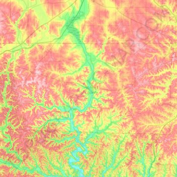
Name: Holmes County topographic map, elevation, terrain.
Location: Holmes County, Ohio, VS (40.44378 -82.22115 40.66841 -81.64890)
Average elevation: 325 m
Minimum elevation: 233 m
Maximum elevation: 419 m
Other topographic maps
Click on a map to view its topography, its elevation and its terrain.
Cuyahoga Valley National Park
Cuyahoga Valley National Park, Boston, Boston Township, Summit County, Ohio, VS
Average elevation: 308 m
Cheviot Hills
VS > Ohio > Cheviot Hills
Cheviot Hills, Clark County, Ohio, 45505, VS
Average elevation: 321 m