
O Vilar topographic map
Interactive map
Click on the map to display elevation.
About this map
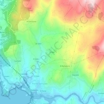
Name: O Vilar topographic map, elevation, terrain.
Location: O Vilar, Ponte Sampaio, Pontevedra, Galicia, 36690, España (42.34277 -8.62119 42.38277 -8.58119)
Average elevation: 153 m
Minimum elevation: -1 m
Maximum elevation: 434 m
Other topographic maps
Click on a map to view its topography, its elevation and its terrain.
O Couso
España > Galicia > Pontevedra > Pontevedra
O Couso, Xeve, Pontevedra, Galicia, 36150, España
Average elevation: 97 m
As Pedrosas
España > Galicia > Pontevedra > Pontevedra
As Pedrosas, Verducido, Pontevedra, Galicia, 36152, España
Average elevation: 139 m