
Norwich topographic map
Click on the map to display elevation.
About this map
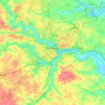
Name: Norwich topographic map, elevation, terrain.
Location: Norwich, Norfolk, England, United Kingdom (52.55544 1.20387 52.68491 1.54078)
Average elevation: 28 m
Minimum elevation: -6 m
Maximum elevation: 74 m
Other topographic maps
Click on a map to view its topography, its elevation and its terrain.
St John's Fen End
United Kingdom > England > Norfolk > King's Lynn and West Norfolk
Average elevation: 1 m
Brandon Bank
United Kingdom > England > Norfolk > King's Lynn and West Norfolk > Feltwell
Average elevation: -1 m
Beacon Hill
United Kingdom > England > Norfolk > North Norfolk
Beacon Hill is a part of the Cromer Ridge which is a ridge of old glacial moraines (terminal moraine) that stands next to the coast above Cromer. The Cromer Ridge seems to have been the front line of the ice sheet for some time at the last glaciations, which is shown by the large size of the feature. All the…
Average elevation: 65 m
Stalham Green
United Kingdom > England > Norfolk > North Norfolk > Stalham Green
Average elevation: 5 m
Sheringham Park
United Kingdom > England > Norfolk > North Norfolk > Upper Sheringham
Average elevation: 61 m
Johnson Street
United Kingdom > England > Norfolk > North Norfolk > Ludham > Johnson Street
Average elevation: 3 m
Castle Rising
United Kingdom > England > Norfolk > King's Lynn and West Norfolk > Castle Rising
Average elevation: 22 m
Poringland Wood
United Kingdom > England > Norfolk > South Norfolk > Framingham Earl
Average elevation: 50 m
Great Witchingham Village Hall Park
United Kingdom > England > Norfolk > Broadland > Lenwade > Great Witchingham
Average elevation: 26 m
Haveringland Lake
United Kingdom > England > Norfolk > Broadland > Haveringland
Average elevation: 39 m
Great Bircham
United Kingdom > England > Norfolk > King's Lynn and West Norfolk
Average elevation: 61 m
North Walsham and Dilham Canal
United Kingdom > England > Norfolk > North Norfolk > Honing
Average elevation: 21 m
Bircham Tofts
United Kingdom > England > Norfolk > King's Lynn and West Norfolk > Great Bircham
Average elevation: 63 m
Brancaster Staithe
United Kingdom > England > Norfolk > King's Lynn and West Norfolk
Average elevation: 18 m
Methwold Hythe
United Kingdom > England > Norfolk > King's Lynn and West Norfolk > Methwold
Average elevation: 8 m
Flaxley
United Kingdom > England > Norfolk > King's Lynn and West Norfolk > Holme next the Sea
Average elevation: 8 m
Fundenhall
United Kingdom > England > Norfolk > South Norfolk > Ashwellthorpe and Fundenhall
Average elevation: 50 m
Old Hunstanton Lighthouse
United Kingdom > England > Norfolk > King's Lynn and West Norfolk > Hunstanton > Old Hunstanton
Average elevation: 9 m
Saham Hills
United Kingdom > England > Norfolk > Breckland District > Saham Toney
Average elevation: 61 m
Ridlington
United Kingdom > England > Norfolk > North Norfolk > Witton and Ridlington
Average elevation: 9 m
Walpole St Andrew
United Kingdom > England > Norfolk > King's Lynn and West Norfolk
Average elevation: 3 m
Ely-Ouse-Essex Water Transfer Scheme
United Kingdom > England > Norfolk > King's Lynn and West Norfolk > Hockwold cum Wilton
Average elevation: 4 m
St John's Highway
United Kingdom > England > Norfolk > King's Lynn and West Norfolk
Average elevation: 2 m