Geolocate

Witcombe topographic map

Click on the map to display elevation.

About this map
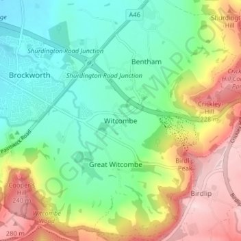
Name: Witcombe topographic map, elevation, terrain.

Location: Witcombe, Tewkesbury, Gloucestershire, England, GL3 4TX, United Kingdom (51.81989 -2.15062 51.85989 -2.11062)

Average elevation: 140 m

Minimum elevation: 44 m

Maximum elevation: 302 m

Other topographic maps

Click on a map to view its topography, its elevation and its terrain.
Tirley

United Kingdom > England > Gloucestershire > Tewkesbury

Average elevation: 19 m

Snowshill

United Kingdom > England > Gloucestershire > Tewkesbury

Average elevation: 249 m

Prescott

United Kingdom > England > Gloucestershire > Tewkesbury

Average elevation: 148 m

Highnam

United Kingdom > England > Gloucestershire > Tewkesbury > Highnam

Average elevation: 21 m

Hawling

United Kingdom > England > Gloucestershire > Tewkesbury

Average elevation: 241 m

Gear up for your next adventure:

🌿Flora and Fauna Field Guides - Identify the plants and animals you encounter on your route
🎒Daypacks - Compact backpacks for short hikes
🐍Snake Gaiters - Protection against snake bites
🧥Packable Rain Jackets - Breathable waterproof layers for unpredictable mountain weather
🚴Bike GPS - GPS devices for cycling

As an Amazon Associate, this site earns from qualifying purchases at no extra cost to you.