
Gemeinde Sibratsgfäll topographic map
Interactive map
Click on the map to display elevation.
About this map
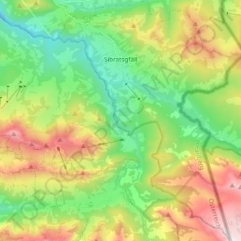
Name: Gemeinde Sibratsgfäll topographic map, elevation, terrain.
Location: Gemeinde Sibratsgfäll, Bezirk Bregenz, Vorarlberg, Austria (47.35986 10.00391 47.44831 10.10559)
Average elevation: 1,245 m
Minimum elevation: 747 m
Maximum elevation: 2,036 m
Sibratsgfäll is located in the westernmost province of Austria, Vorarlberg, in the district of Bregenz, east of Lake Constance, at an altitude of 929 meters. 46.0% of the area is forested, 34.2% mountainous (Alps). The community is located directly on the border with Germany. There are no other cadastral communities in Sibratsgfäll.
Other topographic maps
Click on a map to view its topography, its elevation and its terrain.
Gemeinde Schwarzach
Austria > Vorarlberg > Bezirk Bregenz
Gemeinde Schwarzach, Bezirk Bregenz, Vorarlberg, 6858, Austria
Average elevation: 507 m