
Make a donation
Gear up for your next adventure:
As an Amazon Associate, this site earns from qualifying purchases at no extra cost to you.
Pisco Elqui topographic map
Click on the map to display elevation.
Make a donation
Gear up for your next adventure:
As an Amazon Associate, this site earns from qualifying purchases at no extra cost to you.
About this map
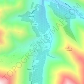
Name: Pisco Elqui topographic map, elevation, terrain.
Average elevation: 1,496 m
Minimum elevation: 1,126 m
Maximum elevation: 2,297 m
Make a donation
Gear up for your next adventure:
As an Amazon Associate, this site earns from qualifying purchases at no extra cost to you.
Other topographic maps
Click on a map to view its topography, its elevation and its terrain.
Vicuña
Chile > Coquimbo Region > Provincia de Elqui
The area is dominated by a mountainous backdrop, and extensive plains on the valley floor, where high-quality grapes for pisco are grown, along with other fruits and vegetables. The La Punilla, Atimonate, Balalita, Los Tilos mountain ranges contain several peaks with altitudes over 4,000 m.
Average elevation: 1,973 m