
Make a donation
Gear up for your next adventure:
As an Amazon Associate, this site earns from qualifying purchases at no extra cost to you.
La Higuera topographic map
Click on the map to display elevation.
Make a donation
Gear up for your next adventure:
As an Amazon Associate, this site earns from qualifying purchases at no extra cost to you.
About this map
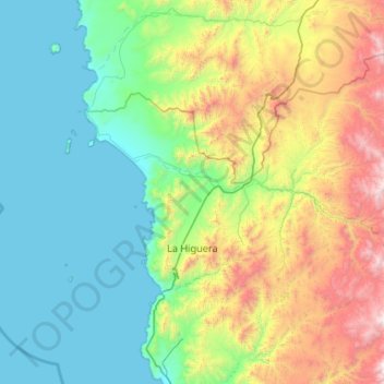
Name: La Higuera topographic map, elevation, terrain.
Location: La Higuera, Provincia de Elqui, Coquimbo Region, Chile (-29.71780 -71.49818 -29.03660 -70.44495)
Average elevation: 629 m
Minimum elevation: 0 m
Maximum elevation: 2,768 m
Make a donation
Gear up for your next adventure:
As an Amazon Associate, this site earns from qualifying purchases at no extra cost to you.
Other topographic maps
Click on a map to view its topography, its elevation and its terrain.
Make a donation
Gear up for your next adventure:
As an Amazon Associate, this site earns from qualifying purchases at no extra cost to you.
Cerro Las Tórtolas
Chile > Coquimbo Region > Provincia de Elqui > Vicuña
Cerro Las Tórtolas is a peak at the border of Argentina and Chile with an elevation of 6,145 metres (20,161 ft) metres and located at the Central Andes. It is on the border of the Argentinean province of San Juan and Chilean province of Elqui. Its slopes are within the administrative boundaries of Argentinean…
Average elevation: 5,610 m
Make a donation
Gear up for your next adventure:
As an Amazon Associate, this site earns from qualifying purchases at no extra cost to you.
Guanaqueros
Chile > Coquimbo Region > Provincia de Elqui > Coquimbo > Guanaqueros
Average elevation: 63 m