Geolocate

Sarver topographic map

Click on the map to display elevation.

About this map
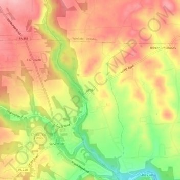
Name: Sarver topographic map, elevation, terrain.

Location: Sarver, Buffalo Township, Butler County, Pennsylvania, 16055, United States (40.71145 -79.76588 40.75145 -79.72588)

Average elevation: 349 m

Minimum elevation: 267 m

Maximum elevation: 404 m

Other topographic maps

Click on a map to view its topography, its elevation and its terrain.

Zelienople

United States > Pennsylvania > Butler County

Zelienople is located in southwestern Butler County, situated on the south bank of Connoquenessing Creek, in an area that is rich with coal and iron ore. The elevation is 935 feet (285 m) above sea level. The borough is bordered by Jackson Township on the north, southeast, and south, and by the borough of…

Average elevation: 305 m

Prospect

United States > Pennsylvania > Butler County

Average elevation: 396 m

Butler

United States > Pennsylvania > Butler County

Average elevation: 339 m

Evans City

United States > Pennsylvania > Butler County

Average elevation: 324 m

Harmony

United States > Pennsylvania > Butler County

Average elevation: 308 m

Mars

United States > Pennsylvania > Butler County

Average elevation: 338 m

East Butler

United States > Pennsylvania > Butler County

Average elevation: 355 m

Petrolia

United States > Pennsylvania > Butler County

Average elevation: 405 m

Saxonburg

United States > Pennsylvania > Butler County

Average elevation: 387 m

Valencia

United States > Pennsylvania > Butler County

Average elevation: 351 m

Butler

United States > Pennsylvania > Butler County

Average elevation: 339 m

Zelienople

United States > Pennsylvania > Butler County

Zelienople is located in southwestern Butler County, situated on the south bank of Connoquenessing Creek, in an area that is rich with coal and iron ore. The elevation is 935 feet (285 m) above sea level. The borough is bordered by Jackson Township on the north, southeast, and south, and by the borough of…

Average elevation: 306 m

Chicora

United States > Pennsylvania > Butler County

Average elevation: 385 m

Valencia

United States > Pennsylvania > Butler County

Average elevation: 351 m

Petrolia

United States > Pennsylvania > Butler County

Average elevation: 405 m

Meridian

United States > Pennsylvania > Butler County

Average elevation: 386 m

Evans City

United States > Pennsylvania > Butler County

Average elevation: 324 m

Gear up for your next adventure:

🦶Orthotic Hiking Insoles - Extra arch support for long-distance topographic treks
🧥Thermal Emergency Blankets - Compact Mylar blankets to prevent hypothermia if stranded overnight
🔑Heavy Duty Carabiners - Secure gear to the outside of your pack for easy access
📖Australian Bush Survival Books - Local knowledge on finding water and surviving the outback
🧊Insulated Cooler Bags - Keep food fresh for day trips to remote geographic sites

As an Amazon Associate, this site earns from qualifying purchases at no extra cost to you.