
Buri Ram Province topographic map
Interactive map
Click on the map to display elevation.
About this map
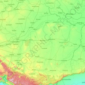
Name: Buri Ram Province topographic map, elevation, terrain.
Location: Buri Ram Province, Thailand (14.13166 102.43553 15.78916 103.50544)
Average elevation: 205 m
Minimum elevation: 24 m
Maximum elevation: 947 m
Other topographic maps
Click on a map to view its topography, its elevation and its terrain.
Ban Kok Khao
Ban Kok Khao, Isan, Buri Ram Province, 31000, Thailand
Average elevation: 182 m
Buri Ram
Buri Ram, Isan, Buri Ram Province, 31009, Thailand
Average elevation: 160 m