
Thank you for supporting this site ❤️
Make a donation
Make a donation
Gear up for your next adventure:
As an Amazon Associate, this site earns from qualifying purchases at no extra cost to you.
Zoetermeer topographic map
Click on the map to display elevation.
Thank you for supporting this site ❤️
Make a donation
Make a donation
Gear up for your next adventure:
As an Amazon Associate, this site earns from qualifying purchases at no extra cost to you.
About this map
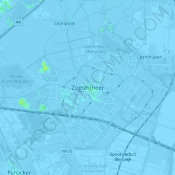
Name: Zoetermeer topographic map, elevation, terrain.
Location: Zoetermeer, South Holland, Netherlands (52.03128 4.41523 52.09329 4.55769)
Average elevation: -3 m
Minimum elevation: -9 m
Maximum elevation: 11 m
Thank you for supporting this site ❤️
Make a donation
Make a donation
Gear up for your next adventure:
As an Amazon Associate, this site earns from qualifying purchases at no extra cost to you.
Other topographic maps
Click on a map to view its topography, its elevation and its terrain.
Capelle aan den IJssel
Netherlands > South Holland > Capelle aan den IJssel
Dutch Topographic map of the municipality of Capelle aan den IJssel, June 2015.
Average elevation: -1 m