
Kabinakagami River topographic map
Interactive map
Click on the map to display elevation.
About this map
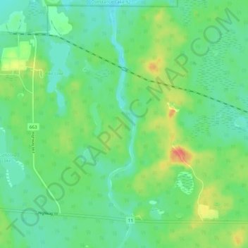
Name: Kabinakagami River topographic map, elevation, terrain.
Average elevation: 250 m
Minimum elevation: 235 m
Maximum elevation: 280 m
Other topographic maps
Click on a map to view its topography, its elevation and its terrain.
Jack Lake
Canada > Ontario > Cochrane District > Unorganized North Cochrane
Jack Lake, Unorganized North Cochrane, Cochrane District, Northeastern Ontario, Ontario, Canada
Average elevation: 274 m
Ptarmigan Lake
Canada > Ontario > Cochrane District > Unorganized North Cochrane
Ptarmigan Lake, Unorganized North Cochrane, Cochrane District, Northeastern Ontario, Ontario, Canada
Average elevation: 225 m
Grant
Canada > Ontario > Cochrane District > Unorganized North Cochrane
Grant, Unorganized North Cochrane, Cochrane District, Northeastern Ontario, Ontario, Canada
Average elevation: 308 m
Sheen Lake
Canada > Ontario > Cochrane District > Unorganized North Cochrane
Sheen Lake, Unorganized North Cochrane, Cochrane District, Northeastern Ontario, Ontario, Canada
Average elevation: 282 m
Snare Lake
Canada > Ontario > Cochrane District > Unorganized North Cochrane
Snare Lake, Unorganized North Cochrane, Cochrane District, Northeastern Ontario, Ontario, Canada
Average elevation: 300 m
Ghost Lake;Pearce Creek
Canada > Ontario > Cochrane District > Unorganized North Cochrane
Ghost Lake;Pearce Creek, Unorganized North Cochrane, Cochrane District, Northeastern Ontario, Ontario, Canada
Average elevation: 213 m
Nipin Lake
Canada > Ontario > Cochrane District > Unorganized North Cochrane
Nipin Lake, Unorganized North Cochrane, Cochrane District, Northeastern Ontario, Ontario, Canada
Average elevation: 263 m
Teal Creek
Canada > Ontario > Cochrane District > Unorganized North Cochrane
Teal Creek, Unorganized North Cochrane, Cochrane District, Northeastern Ontario, Ontario, Canada
Average elevation: 203 m
Richter Lake
Canada > Ontario > Cochrane District > Unorganized North Cochrane
Richter Lake, Unorganized North Cochrane, Cochrane District, Northeastern Ontario, Ontario, Canada
Average elevation: 202 m
Hunta
Canada > Ontario > Cochrane District > Unorganized North Cochrane
Hunta, Unorganized North Cochrane, Cochrane District, Northeastern Ontario, Ontario, Canada
Average elevation: 272 m
Smoky Falls
Canada > Ontario > Cochrane District > Unorganized North Cochrane
Smoky Falls, Unorganized North Cochrane, Cochrane District, Northeastern Ontario, Ontario, Canada
Average elevation: 170 m