
Make a donation
Gear up for your next adventure:
As an Amazon Associate, this site earns from qualifying purchases at no extra cost to you.
Gerolfingen topographic map
Click on the map to display elevation.
Make a donation
Gear up for your next adventure:
As an Amazon Associate, this site earns from qualifying purchases at no extra cost to you.
About this map
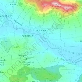
Name: Gerolfingen topographic map, elevation, terrain.
Average elevation: 472 m
Minimum elevation: 421 m
Maximum elevation: 686 m
Make a donation
Gear up for your next adventure:
As an Amazon Associate, this site earns from qualifying purchases at no extra cost to you.
Other topographic maps
Click on a map to view its topography, its elevation and its terrain.
Wehlmäusel
Deutschland > Bayern > Landkreis Ansbach > Feuchtwangen > Weikersdorf
Average elevation: 470 m
Make a donation
Gear up for your next adventure:
As an Amazon Associate, this site earns from qualifying purchases at no extra cost to you.
Kleiner Lindleinsee
Deutschland > Bayern > Landkreis Ansbach > Rothenburg ob der Tauber
Average elevation: 408 m
Make a donation
Gear up for your next adventure:
As an Amazon Associate, this site earns from qualifying purchases at no extra cost to you.
Make a donation
Gear up for your next adventure:
As an Amazon Associate, this site earns from qualifying purchases at no extra cost to you.
Hesselberg
Deutschland > Bayern > Landkreis Ansbach > Gerolfingen
Die tiefbraunen Verwitterungsfarben der höheren Schichten geben dem Braunen Jura seinen Namen. Ursache ist der höhere Eisengehalt. Insgesamt bildet die 135 m mächtige Schicht des Dogger den Hauptanstieg der Hesselberghänge. Die unterste Schicht ist der 75 m mächtige „Opalinuston“ (heute…
Average elevation: 525 m
Make a donation
Gear up for your next adventure:
As an Amazon Associate, this site earns from qualifying purchases at no extra cost to you.
Hemmendorf
Deutschland > Bayern > Landkreis Ansbach > Rothenburg ob der Tauber
Average elevation: 444 m
Make a donation
Gear up for your next adventure:
As an Amazon Associate, this site earns from qualifying purchases at no extra cost to you.
Make a donation
Gear up for your next adventure:
As an Amazon Associate, this site earns from qualifying purchases at no extra cost to you.
Roth
Deutschland > Bayern > Landkreis Ansbach > Herrieden
Im Geographischen statistisch-topographischen Lexikon von Franken (1801) wird der Ort folgendermaßen beschrieben.
Average elevation: 431 m
Make a donation
Gear up for your next adventure:
As an Amazon Associate, this site earns from qualifying purchases at no extra cost to you.
Brundorf
Deutschland > Bayern > Landkreis Ansbach > Rothenburg ob der Tauber > Leuzenbronn
Average elevation: 440 m
Make a donation
Gear up for your next adventure:
As an Amazon Associate, this site earns from qualifying purchases at no extra cost to you.
Make a donation
Gear up for your next adventure:
As an Amazon Associate, this site earns from qualifying purchases at no extra cost to you.
Bonlanden
Deutschland > Bayern > Landkreis Ansbach > Feuchtwangen > Oberdallersbach
Average elevation: 477 m
Make a donation
Gear up for your next adventure:
As an Amazon Associate, this site earns from qualifying purchases at no extra cost to you.
Reusch
Deutschland > Bayern > Landkreis Ansbach > Rothenburg ob der Tauber > Bettenfeld
Etwa einen Kilometer nordöstlich des Weilers liegt die Bossendorfer Höhe (467 m ü. NHN), 1 km südöstlich liegt die Schandtauberhöhle, die zugleich ein Naturschutzgebiet ist. Gemeindeverbindungsstraßen führen nach Bossendorf zur Landesstraße 1022 (1 km nördlich), zur L 1005 bei Leuzendorf (1,2 km…
Average elevation: 455 m
Geilsheim
Deutschland > Bayern > Landkreis Ansbach > Wassertrüdingen
Beim Wettbewerb „Unser Dorf soll schöner werden“ erhielt Geilsheim 1981 die Goldmedaille der Bayerischen Staatsregierung. Der Ort wird durch ein reichhaltiges kulturelles Leben sowie den großen Zusammenhalt unter den Einwohnern geprägt. So ist es auch nicht verwunderlich, dass die Theateraufführungen…
Average elevation: 469 m
Make a donation
Gear up for your next adventure:
As an Amazon Associate, this site earns from qualifying purchases at no extra cost to you.
Make a donation
Gear up for your next adventure:
As an Amazon Associate, this site earns from qualifying purchases at no extra cost to you.
Make a donation
Gear up for your next adventure:
As an Amazon Associate, this site earns from qualifying purchases at no extra cost to you.
Schnepfendorf
Deutschland > Bayern > Landkreis Ansbach > Rothenburg ob der Tauber
Average elevation: 450 m
Make a donation
Gear up for your next adventure:
As an Amazon Associate, this site earns from qualifying purchases at no extra cost to you.
Make a donation
Gear up for your next adventure:
As an Amazon Associate, this site earns from qualifying purchases at no extra cost to you.
Make a donation
Gear up for your next adventure:
As an Amazon Associate, this site earns from qualifying purchases at no extra cost to you.
Dietenhofen
Deutschland > Bayern > Landkreis Ansbach > Dietenhofen > Dietenhofen
Average elevation: 392 m
Glashofen
Deutschland > Bayern > Landkreis Ansbach > Feuchtwangen > Oberdallersbach
Average elevation: 485 m
Make a donation
Gear up for your next adventure:
As an Amazon Associate, this site earns from qualifying purchases at no extra cost to you.
Make a donation
Gear up for your next adventure:
As an Amazon Associate, this site earns from qualifying purchases at no extra cost to you.
Make a donation
Gear up for your next adventure:
As an Amazon Associate, this site earns from qualifying purchases at no extra cost to you.
Make a donation
Gear up for your next adventure:
As an Amazon Associate, this site earns from qualifying purchases at no extra cost to you.
Elpersdorf bei Windsbach
Deutschland > Bayern > Landkreis Ansbach > Windsbach
Average elevation: 406 m
Make a donation
Gear up for your next adventure:
As an Amazon Associate, this site earns from qualifying purchases at no extra cost to you.