
São Jorge topographic map
Interactive map
Click on the map to display elevation.
About this map
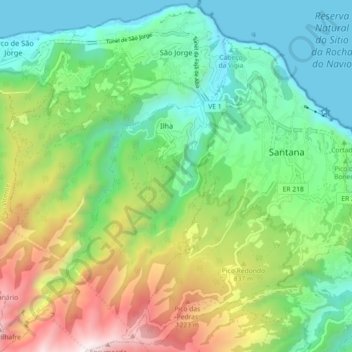
Name: São Jorge topographic map, elevation, terrain.
Location: São Jorge, Santana, Madeira, 9230-142, Portugal (32.76174 -16.96055 32.83761 -16.89639)
Average elevation: 581 m
Minimum elevation: -1 m
Maximum elevation: 1,767 m
Fifty kilometres from the regional capital, the parish is located 240 metres above sea level, limited in the north by the Atlantic Ocean and south by the mountains of the interior range (the heightest altitudes in the parish include Pico Canário 1,592 metres (5,223 ft) and Pico dos Assumadouros 1,184 metres (3,885 ft). To the west is the civil parish of Arco de São Jorge and east are the parishes of Ilha and Santana. About half of the parish is covered by the rich Laurissilva forest defined as Natural Heritage by UNESCO.
Other topographic maps
Click on a map to view its topography, its elevation and its terrain.
São Roque do Faial
São Roque do Faial, Santana, Madeira, Portugal
Average elevation: 632 m
Praia de S. Jorge
Portugal > Santana > Calhau São Jorge
Praia de S. Jorge, Calhau, Calhau São Jorge, Santana, 9230-111, Portugal
Average elevation: 121 m