
Lisse topographic map
Interactive map
Click on the map to display elevation.
About this map
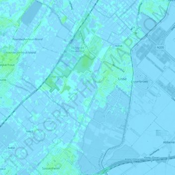
Name: Lisse topographic map, elevation, terrain.
Location: Lisse, Zuid-Holland, Nederland (52.22221 4.51352 52.28664 4.57275)
Average elevation: -1 m
Minimum elevation: -8 m
Maximum elevation: 6 m
Other topographic maps
Click on a map to view its topography, its elevation and its terrain.
Kasteel Keukenhof
Nederland > Zuid-Holland > Lisse
Kasteel Keukenhof, Keukenhof, Lisse, Zuid-Holland, Nederland, 2161AN, Nederland
Average elevation: 1 m
Leidse Trekvaart
Nederland > Zuid-Holland > Lisse
Leidse Trekvaart, Lisse, Zuid-Holland, Nederland, 2211VL, Nederland
Average elevation: 0 m