
Charles County topographic map
Interactive map
Click on the map to display elevation.
About this map
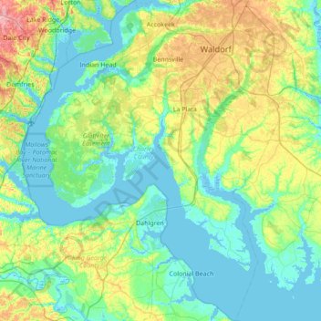
Name: Charles County topographic map, elevation, terrain.
Location: Charles County, Maryland, Verenigde Staten (38.17133 -77.32353 38.70727 -76.66248)
Average elevation: 27 m
Minimum elevation: -6 m
Maximum elevation: 119 m
Other topographic maps
Click on a map to view its topography, its elevation and its terrain.
Mount Rainier
Verenigde Staten > Maryland > Prince George's County
Mount Rainier, Prince George's County, Maryland, 20712, Verenigde Staten
Average elevation: 20 m
Glen Burnie
Verenigde Staten > Maryland > Anne Arundel County
Glen Burnie, Anne Arundel County, Maryland, 21061, Verenigde Staten
Average elevation: 37 m
Somerset Manor
Verenigde Staten > Maryland > Harford County > Havre de Grace
Somerset Manor, Havre de Grace, Harford County, Maryland, 21078, Verenigde Staten
Average elevation: 28 m
Madonna
Verenigde Staten > Maryland > Harford County
Madonna, Harford County, Maryland, 21084, Verenigde Staten
Average elevation: 199 m
Baltimore Highlands
Verenigde Staten > Maryland > Baltimore County > Baltimore Highlands
Baltimore Highlands, Baltimore County, Maryland, Verenigde Staten
Average elevation: 15 m
Reid
Verenigde Staten > Maryland > Reid
Reid, Washington County, Maryland, 17263, Verenigde Staten
Average elevation: 188 m