
Baltimore topographic map
Interactive map
Click on the map to display elevation.
About this map
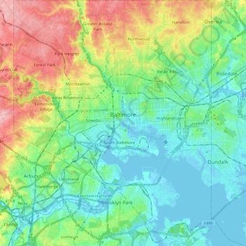
Name: Baltimore topographic map, elevation, terrain.
Location: Baltimore, Maryland, United States (39.19723 -76.71130 39.37200 -76.52968)
Average elevation: 47 m
Minimum elevation: -4 m
Maximum elevation: 158 m
Baltimore is in north-central Maryland on the Patapsco River close to where it empties into the Chesapeake Bay. The city is also located on the fall line between the Piedmont Plateau and the Atlantic coastal plain, which divides Baltimore into "lower city" and "upper city". The city's elevation ranges from sea level at the harbor to 480 feet (150 m) in the northwest corner near Pimlico.
Other topographic maps
Click on a map to view its topography, its elevation and its terrain.
Baltimore County
Baltimore County, Maryland, United States
Average elevation: 123 m
Kings Manor South
United States > Maryland > Charles County
Kings Manor South, Charles County, Maryland, 20695, United States
Average elevation: 59 m
Linden Springs
United States > Maryland > Baltimore County
Linden Springs, Baltimore County, Maryland, 21053, United States
Average elevation: 253 m
Solomons Island
United States > Maryland > Calvert County > Solomons
Solomons Island, Solomons, Calvert County, Maryland, 20688, United States
Average elevation: 11 m
Forest Glen
United States > Maryland > Montgomery County > Forest Glen > McKenney Hills
Forest Glen, McKenney Hills, Forest Glen, Montgomery County, Maryland, United States
Average elevation: 105 m
Deer Park Ridge
United States > Maryland > Carroll County
Deer Park Ridge, Carroll County, Maryland, 21048, United States
Average elevation: 156 m
Cumberland
United States > Maryland > Allegany County
Cumberland, Allegany County, Maryland, 21502, United States
Average elevation: 264 m
Assateague Island
United States > Maryland > Worcester County > West Ocean City
Assateague Island, West Ocean City, Worcester County, Maryland, United States
Average elevation: 3 m
Treetops
United States > Maryland > Baltimore County
Treetops, Baltimore County, Maryland, United States
Average elevation: 131 m
Gaithersburg
United States > Maryland > Montgomery County
Gaithersburg, Montgomery County, Maryland, United States
Average elevation: 137 m
Upperco
United States > Maryland > Baltimore County
Upperco, Baltimore County, Maryland, 21155, United States
Average elevation: 218 m
Easton Primary Sewage Lagoon Dam
United States > Maryland > Talbot County
Easton Primary Sewage Lagoon Dam, Talbot County, Maryland, United States
Average elevation: 9 m
Parkville
United States > Maryland > Baltimore County
Parkville, Baltimore County, Maryland, 21234, United States
Average elevation: 91 m
Stevensville
United States > Maryland > Queen Anne's County
Stevensville, Queen Anne's County, Maryland, United States
Average elevation: 2 m
Blackhole Creek
United States > Maryland > Anne Arundel County > Cape Sable
Blackhole Creek, Cape Sable, Anne Arundel County, Maryland, 21012, United States
Average elevation: 4 m
Simpsons Farm
United States > Maryland > Calvert County
Simpsons Farm, Calvert County, Maryland, 20736, United States
Average elevation: 38 m
Bradbury Park
United States > Maryland > Prince George's County > Suitland
Bradbury Park, Suitland, Prince George's County, Maryland, 20233, United States
Average elevation: 80 m
Bonnie Brook
United States > Maryland > Dorchester County
Bonnie Brook, Dorchester County, Maryland, United States
Average elevation: 5 m
Middle East
United States > Maryland > Baltimore
Middle East, Baltimore, Maryland, United States
Average elevation: 29 m
Calvert County
Calvert County, Maryland, United States
Average elevation: 18 m
Reisterstown
United States > Maryland > Baltimore County > Reisterstown
Reisterstown, Baltimore County, Maryland, 21136, United States
Average elevation: 199 m
Pikesville
United States > Maryland > Baltimore County > Pikesville
Pikesville, Baltimore County, Maryland, United States
Average elevation: 135 m
Edmondson Village
United States > Maryland > Baltimore
Edmondson Village, Baltimore, Maryland, United States
Average elevation: 80 m
Skeleton Creek
United States > Maryland > Caroline County
Skeleton Creek, Caroline County, Maryland, 21609, United States
Average elevation: 5 m
Middle River
United States > Maryland > Baltimore County > Middle River
Middle River, Baltimore County, Maryland, 21220, United States
Average elevation: 13 m
White Marsh
United States > Maryland > Baltimore County > White Marsh
White Marsh, Baltimore County, Maryland, United States
Average elevation: 39 m
Forest Glen
United States > Maryland > Montgomery County
Forest Glen, Montgomery County, Maryland, 20895, United States
Average elevation: 96 m
Woodberry
United States > Maryland > Baltimore
Woodberry, Baltimore, Maryland, United States
Average elevation: 94 m
Rosedale
United States > Maryland > Baltimore County > Rosedale
Rosedale, Baltimore County, Maryland, 21237, United States
Average elevation: 28 m
Mutual Consent
United States > Maryland > Calvert County
Mutual Consent, Calvert County, Maryland, 20676, United States
Average elevation: 32 m
Sams Creek
United States > Maryland > Frederick County
Sams Creek, Frederick County, Maryland, 21776, United States
Average elevation: 189 m
East Riverdale
United States > Maryland > Prince George's County > East Riverdale
East Riverdale, Prince George's County, Maryland, 20737, United States
Average elevation: 36 m
Rockville
United States > Maryland > Montgomery County
Rockville, Montgomery County, Maryland, United States
Average elevation: 122 m
Owings Mills
United States > Maryland > Baltimore County > Owings Mills
Owings Mills, Baltimore County, Maryland, 21117, United States
Average elevation: 173 m
Ferry Road
United States > Maryland > Wicomico County
Ferry Road, Wicomico County, Maryland, 21810, United States
Average elevation: 7 m
Dundalk
United States > Maryland > Baltimore County > Dundalk
Dundalk, Baltimore County, Maryland, 21222, United States
Average elevation: 6 m
Queensberry
United States > Maryland > Calvert County > Prince Frederick > Queensberry
Queensberry, Prince Frederick, Calvert County, Maryland, 20678, United States
Average elevation: 37 m
Jersey Island
United States > Maryland > Somerset County > Crisfield
Jersey Island, Crisfield, Somerset County, Maryland, 21817, United States
Average elevation: 2 m
Queenland
United States > Maryland > Prince George's County > Rosaryville
Queenland, Rosaryville, Prince George's County, Maryland, 20772, United States
Average elevation: 42 m
Jacksonville
United States > Maryland > Baltimore County > Jacksonville
Jacksonville, Baltimore County, Maryland, 21131, United States
Average elevation: 170 m
Washington, Baltimore & Annapolis Trail
United States > Maryland > Prince George's County > Bowie
Washington, Baltimore & Annapolis Trail, Bowie, Prince George's County, Maryland, United States
Average elevation: 31 m
Dargan
United States > Maryland > Washington County > Dargan
Dargan, Washington County, Maryland, 25410, United States
Average elevation: 158 m
Potomac Vista
United States > Maryland > Prince George's County > National Harbor > Potomac Vista
Potomac Vista, National Harbor, Prince George's County, Maryland, 20745-3027, United States
Average elevation: 26 m
Abell
United States > Maryland > Saint Mary's County > Abell
Abell, Saint Mary's County, Maryland, 20606, United States
Average elevation: 3 m
Frostburg
United States > Maryland > Allegany County > Frostburg
Frostburg, Allegany County, Maryland, 21532, United States
Average elevation: 620 m
Westernport
United States > Maryland > Allegany County > Westernport
Westernport, Allegany County, Maryland, United States
Average elevation: 400 m
Columbia
United States > Maryland > Howard County > Columbia
Columbia, Howard County, Maryland, United States
Average elevation: 114 m
Germantown
United States > Maryland > Montgomery County > Germantown
Germantown, Montgomery County, Maryland, United States
Average elevation: 130 m
Zekiah Valley
United States > Maryland > Charles County > Zekiah Valley
Zekiah Valley, Charles County, Maryland, 20617, United States
Average elevation: 44 m
Jackson Landing
United States > Maryland > Prince George's County > Jackson Landing
Jackson Landing, Prince George's County, Maryland, United States
Average elevation: 15 m