
Make a donation
Gear up for your next adventure:
As an Amazon Associate, this site earns from qualifying purchases at no extra cost to you.
Arusha topographic map
Click on the map to display elevation.
Make a donation
Gear up for your next adventure:
As an Amazon Associate, this site earns from qualifying purchases at no extra cost to you.
Arusha
The Great Rift Valley runs through the middle of the region north-to-south. Oldonyo Lengai (Mountain of God in the Maasai language) is an active volcano to the north of the Ngorongoro Conservation Area. Altitudes throughout the region vary widely, but much of it ranges from 900 to 1,600 metres (3,000 to 5,200 ft) in elevation.
Make a donation
Gear up for your next adventure:
As an Amazon Associate, this site earns from qualifying purchases at no extra cost to you.
About this map
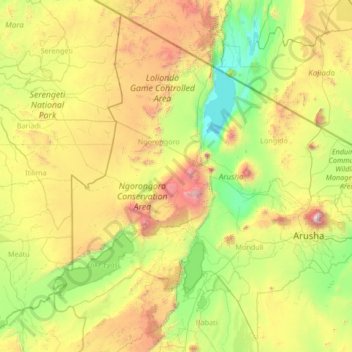
Name: Arusha topographic map, elevation, terrain.
Location: Arusha, Northern Zone, Tanzania (-4.15051 34.75004 -1.68655 37.42877)
Average elevation: 1,440 m
Minimum elevation: 594 m
Maximum elevation: 4,271 m
Make a donation
Gear up for your next adventure:
As an Amazon Associate, this site earns from qualifying purchases at no extra cost to you.
Other topographic maps
Click on a map to view its topography, its elevation and its terrain.
Kilimanjaro
Kilimanjaro is the fourth most topographically prominent peak on Earth. It is part of Kilimanjaro National Park and is a major hiking and climbing destination. Because of its shrinking glaciers and ice fields, which are projected to disappear between 2025 and 2035, it has been the subject of many scientific…
Average elevation: 5,663 m
Make a donation
Gear up for your next adventure:
As an Amazon Associate, this site earns from qualifying purchases at no extra cost to you.
Make a donation
Gear up for your next adventure:
As an Amazon Associate, this site earns from qualifying purchases at no extra cost to you.
Make a donation
Gear up for your next adventure:
As an Amazon Associate, this site earns from qualifying purchases at no extra cost to you.
Make a donation
Gear up for your next adventure:
As an Amazon Associate, this site earns from qualifying purchases at no extra cost to you.
Make a donation
Gear up for your next adventure:
As an Amazon Associate, this site earns from qualifying purchases at no extra cost to you.
Kitongoji cha Makanisani
Tanzania > Simiyu > Lamadi > Kitongoji cha Makanisani
Average elevation: 1,140 m