
Make a donation
Gear up for your next adventure:
As an Amazon Associate, this site earns from qualifying purchases at no extra cost to you.
Schwabsoien topographic map
Click on the map to display elevation.
Make a donation
Gear up for your next adventure:
As an Amazon Associate, this site earns from qualifying purchases at no extra cost to you.
Schwabsoien
Schwabsoien liegt in der Region Oberland am Nordwestrand des Pfaffenwinkels in einer Höhenlage von 730 bis 860 m ü. NHN.
Make a donation
Gear up for your next adventure:
As an Amazon Associate, this site earns from qualifying purchases at no extra cost to you.
About this map
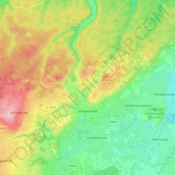
Name: Schwabsoien topographic map, elevation, terrain.
Average elevation: 770 m
Minimum elevation: 697 m
Maximum elevation: 867 m
Make a donation
Gear up for your next adventure:
As an Amazon Associate, this site earns from qualifying purchases at no extra cost to you.
Other topographic maps
Click on a map to view its topography, its elevation and its terrain.
Make a donation
Gear up for your next adventure:
As an Amazon Associate, this site earns from qualifying purchases at no extra cost to you.
Make a donation
Gear up for your next adventure:
As an Amazon Associate, this site earns from qualifying purchases at no extra cost to you.
Make a donation
Gear up for your next adventure:
As an Amazon Associate, this site earns from qualifying purchases at no extra cost to you.
Weilheim in Oberbayern
Deutschland > Bayern > Landkreis Weilheim-Schongau > Weilheim in Oberbayern
Average elevation: 584 m
Make a donation
Gear up for your next adventure:
As an Amazon Associate, this site earns from qualifying purchases at no extra cost to you.
Hoher Peißenberg
Deutschland > Bayern > Landkreis Weilheim-Schongau > Hohenpeißenberg
Der Hohe Peißenberg gehört in der naturräumlichen Haupteinheitengruppe Subalpines Jungmoränenland (Nr. 03), in der Haupteinheit Ammer-Loisach-Isar-Jungmoränenland (037) und in der Untereinheit Hügel- und Moorland des Ammersees (037.0) zum Naturraum Peißenbergkämme (037.09). Seine Landschaft fällt etwa…
Average elevation: 810 m
Make a donation
Gear up for your next adventure:
As an Amazon Associate, this site earns from qualifying purchases at no extra cost to you.
Lexe
Deutschland > Bayern > Landkreis Weilheim-Schongau > Peiting > Herzogsägmühle
Average elevation: 715 m
Make a donation
Gear up for your next adventure:
As an Amazon Associate, this site earns from qualifying purchases at no extra cost to you.
Vogelfreistätte Ammersee-Südufer
Deutschland > Bayern > Landkreis Weilheim-Schongau > Aidenried
Average elevation: 536 m
Make a donation
Gear up for your next adventure:
As an Amazon Associate, this site earns from qualifying purchases at no extra cost to you.
Make a donation
Gear up for your next adventure:
As an Amazon Associate, this site earns from qualifying purchases at no extra cost to you.
Make a donation
Gear up for your next adventure:
As an Amazon Associate, this site earns from qualifying purchases at no extra cost to you.
Rameck
Deutschland > Bayern > Landkreis Weilheim-Schongau > Huglfing > Huglfing > Rameck
Average elevation: 621 m
Ficht
Deutschland > Bayern > Landkreis Weilheim-Schongau > Peißenberg > Ficht
Average elevation: 586 m
Make a donation
Gear up for your next adventure:
As an Amazon Associate, this site earns from qualifying purchases at no extra cost to you.
Steinfall
Deutschland > Bayern > Landkreis Weilheim-Schongau > Hohenpeißenberg
Average elevation: 743 m
Make a donation
Gear up for your next adventure:
As an Amazon Associate, this site earns from qualifying purchases at no extra cost to you.