
Make a donation
Gear up for your next adventure:
As an Amazon Associate, this site earns from qualifying purchases at no extra cost to you.
Paterzell topographic map
Click on the map to display elevation.
Make a donation
Gear up for your next adventure:
As an Amazon Associate, this site earns from qualifying purchases at no extra cost to you.
About this map
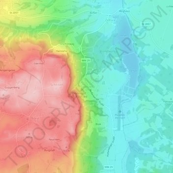
Name: Paterzell topographic map, elevation, terrain.
Average elevation: 665 m
Minimum elevation: 576 m
Maximum elevation: 796 m
Make a donation
Gear up for your next adventure:
As an Amazon Associate, this site earns from qualifying purchases at no extra cost to you.
Other topographic maps
Click on a map to view its topography, its elevation and its terrain.
Make a donation
Gear up for your next adventure:
As an Amazon Associate, this site earns from qualifying purchases at no extra cost to you.
Weilheim in Oberbayern
Deutschland > Bayern > Landkreis Weilheim-Schongau
Besonders der Gletschervorstoß in der Würm-Kaltzeit, welche vor 115.000 Jahren begann und vor etwa 15.000 Jahren endete hat das heutige Landschaftsbild der Region wie auch des gesamten nördlichen Alpenvorlandes stark geprägt. So ist beispielsweise das „Gögerl“ südlich von Weilheim dadurch entstanden,…
Average elevation: 596 m
Make a donation
Gear up for your next adventure:
As an Amazon Associate, this site earns from qualifying purchases at no extra cost to you.
Wessobrunn
Deutschland > Bayern > Landkreis Weilheim-Schongau
Wessobrunn liegt auf einer Höhe von 701 Meter ü. d. M. südwestlich des Ammersees, nordwestlich von Weilheim und südöstlich von Landsberg am Lech. Das Gemeindegebiet zieht sich vom Forst Bayerdießen zum Fuß des Hohen Peißenberg. Von den 5110 ha Gemeindefläche sind 3035 ha landwirtschaftliche…
Average elevation: 683 m
Ingenried
Deutschland > Bayern > Landkreis Weilheim-Schongau
Ingenried liegt in der Region Oberland am Westrand des Pfaffenwinkels auf rund 800 m Höhe.
Average elevation: 813 m
Make a donation
Gear up for your next adventure:
As an Amazon Associate, this site earns from qualifying purchases at no extra cost to you.
Schwabsoien
Deutschland > Bayern > Landkreis Weilheim-Schongau
Schwabsoien liegt in der Region Oberland am Nordwestrand des Pfaffenwinkels in einer Höhenlage von 730 bis 860 m ü. NHN.
Average elevation: 770 m
Make a donation
Gear up for your next adventure:
As an Amazon Associate, this site earns from qualifying purchases at no extra cost to you.
Make a donation
Gear up for your next adventure:
As an Amazon Associate, this site earns from qualifying purchases at no extra cost to you.
Make a donation
Gear up for your next adventure:
As an Amazon Associate, this site earns from qualifying purchases at no extra cost to you.
Make a donation
Gear up for your next adventure:
As an Amazon Associate, this site earns from qualifying purchases at no extra cost to you.
82393
Deutschland > Bayern > Landkreis Weilheim-Schongau > Iffeldorf > Staltach
Average elevation: 595 m
86971
Deutschland > Bayern > Landkreis Weilheim-Schongau > Peiting > Hausen > Hohenbrand
Average elevation: 729 m
Make a donation
Gear up for your next adventure:
As an Amazon Associate, this site earns from qualifying purchases at no extra cost to you.
Vogelfreistätte Ammersee-Südufer
Deutschland > Bayern > Landkreis Weilheim-Schongau > Aidenried
Average elevation: 536 m
Make a donation
Gear up for your next adventure:
As an Amazon Associate, this site earns from qualifying purchases at no extra cost to you.
Bernried am Starnberger See
Deutschland > Bayern > Landkreis Weilheim-Schongau
Die Gemeinde Bernried lockte einige Künstler an. 1998 kam es zum Bau des „Buchheim-Museums der Phantasie“ im Hirschgartengelände in Höhenried, das seit 1999 ein großer Anziehungspunkt für Besucher aus aller Welt ist.
Average elevation: 599 m
82386
Deutschland > Bayern > Landkreis Weilheim-Schongau > Huglfing > Schweyer
Average elevation: 614 m
Iffeldorf
Deutschland > Bayern > Landkreis Weilheim-Schongau
Das Dorf wurde erstmals im Jahr 1080 erwähnt und war vom 14. Jahrhundert bis 1653 im Besitz der Edlen von Höhenkirchen. Anschließend war Iffeldorf bis zur Säkularisation im Besitz des Klosters Wessobrunn. Von etwa 1860 bis 1961 war die Gemeinde stark durch den Gutsbetrieb Staltach der Familie Maffei…
Average elevation: 610 m
Make a donation
Gear up for your next adventure:
As an Amazon Associate, this site earns from qualifying purchases at no extra cost to you.
Huglfing
Deutschland > Bayern > Landkreis Weilheim-Schongau
Umgeben von eiszeitlichen Moränenhügeln liegt der Ort Huglfing auf einer Höhe von 625 m ü. NHN. Durch das Tal zieht sich der Hungerbach. Huglfing liegt an der Bahnstrecke München–Garmisch-Partenkirchen, etwa 60 km südlich von München. Die Bundesstraße 472 von Bad Tölz nach Schongau führt durch die…
Average elevation: 640 m
Make a donation
Gear up for your next adventure:
As an Amazon Associate, this site earns from qualifying purchases at no extra cost to you.
82362
Deutschland > Bayern > Landkreis Weilheim-Schongau > Weilheim in Oberbayern
Average elevation: 570 m
Seeshaupt
Deutschland > Bayern > Landkreis Weilheim-Schongau
Die Gemeinde liegt in der Region Oberland am Südende des Starnberger Sees. Das Gemeindegebiet erstreckt sich vom Seeufer nach Süden zu den Osterseen, deren nördlicher Teil ab dem Stechsee, sowie der Frechensee im Gemeindegebiet liegen. Im Westen zieht sich das Gemeindegebiet auf den Höhenrücken zwischen…
Average elevation: 612 m
Make a donation
Gear up for your next adventure:
As an Amazon Associate, this site earns from qualifying purchases at no extra cost to you.
Make a donation
Gear up for your next adventure:
As an Amazon Associate, this site earns from qualifying purchases at no extra cost to you.
Weilheim in Oberbayern
Deutschland > Bayern > Landkreis Weilheim-Schongau
Besonders der Gletschervorstoß in der Würm-Kaltzeit, welche vor 115.000 Jahren begann und vor etwa 15.000 Jahren endete hat das heutige Landschaftsbild der Region wie auch des gesamten nördlichen Alpenvorlandes stark geprägt. So ist beispielsweise das „Gögerl“ südlich von Weilheim dadurch entstanden,…
Average elevation: 595 m