
Kirkel topographic map
Interactive map
Click on the map to display elevation.
About this map
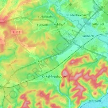
Name: Kirkel topographic map, elevation, terrain.
Location: Kirkel, Saarpfalz-Kreis, Saarland, 66459, Germany (49.25977 7.18461 49.34050 7.31642)
Average elevation: 278 m
Minimum elevation: 215 m
Maximum elevation: 386 m
Other topographic maps
Click on a map to view its topography, its elevation and its terrain.
Schüren
Germany > Saarland > Saarpfalz-Kreis > Sankt Ingbert
Schüren, St. Ingbert, Sankt Ingbert, Saarpfalz-Kreis, Saarland, Germany
Average elevation: 307 m
Blieskastel
Germany > Saarland > Saarpfalz-Kreis
Blieskastel, Saarpfalz-Kreis, Saarland, 66440, Germany
Average elevation: 294 m
Bexbach
Germany > Saarland > Saarpfalz-Kreis
Bexbach, Saarpfalz-Kreis, Saarland, 66450, Germany
Average elevation: 308 m
Webenheim
Germany > Saarland > Saarpfalz-Kreis > Blieskastel
Webenheim, Blieskastel, Saarpfalz-Kreis, Saarland, Germany
Average elevation: 276 m
Sankt Ingbert
Germany > Saarland > Saarpfalz-Kreis
Sankt Ingbert, Saarpfalz-Kreis, Saarland, 66386, Germany
Average elevation: 291 m