
Dongo-ri topographic map
Interactive map
Click on the map to display elevation.
About this map
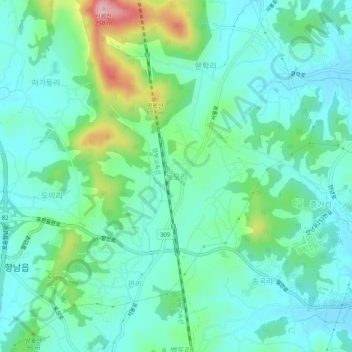
Name: Dongo-ri topographic map, elevation, terrain.
Location: Dongo-ri, Hwaseong-si, 18588, South Korea (37.11969 126.93526 37.15969 126.97526)
Average elevation: 69 m
Minimum elevation: 18 m
Maximum elevation: 234 m
Other topographic maps
Click on a map to view its topography, its elevation and its terrain.
Hyangnam
Hyangnam, Hwaseong-si, Gyeonggi, 18600, South Korea
Average elevation: 48 m
Baekto-ri
Baekto-ri, Hwaseong-si, Gyeonggi, 18589, South Korea
Average elevation: 58 m
Songgok-ri
South Korea > Hwaseong-si > Songgok-ri
Songgok-ri, Hwaseong-si, Gyeonggi, 18589, South Korea
Average elevation: 55 m