Geolocate

Rønde topographic map

Click on the map to display elevation.

Rønde

Rønde is a hill town, with a 95-meter difference in elevation between the lowest and highest part. This kind of grade difference is unusual for Denmark, where the overall highest point in the country is 172 meters above sea level.

About this map
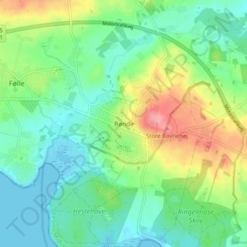
Name: Rønde topographic map, elevation, terrain.

Location: Rønde, Syddjurs Municipality, Central Denmark Region, 8410, Denmark (56.28156 10.45544 56.32156 10.49544)

Average elevation: 31 m

Minimum elevation: -2 m

Maximum elevation: 96 m

Other topographic maps

Click on a map to view its topography, its elevation and its terrain.

Gear up for your next adventure:

🩹Wilderness First Aid Kits - Comprehensive medical kits tailored for hiking and remote exploration
🎒3L Hydration Reservoirs - Hands-free drinking to stay hydrated on steep contour climbs
🚴Bike GPS - GPS devices for cycling
GPS Watches - GPS watches for outdoor sports
🧊Insulated Stainless Steel Flasks - Keep water cold for 24 hours in the heat or coffee hot in the cold

As an Amazon Associate, this site earns from qualifying purchases at no extra cost to you.