
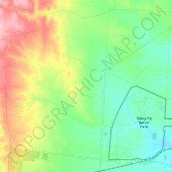
Monarto topographic map
Interactive map
Click on the map to display elevation.
About this map
Name: Monarto topographic map, elevation, terrain.
Average elevation: 148 m
Minimum elevation: 77 m
Maximum elevation: 265 m
Other topographic maps
Click on a map to view its topography, its elevation and its terrain.
Mypolonga
Australia > South Australia > The Rural City of Murray Bridge
Mypolonga, The Rural City of Murray Bridge, South Australia, 5254, Australia
Average elevation: 44 m
Toora
Australia > South Australia > The Rural City of Murray Bridge
Toora, The Rural City of Murray Bridge, South Australia, 5253, Australia
Average elevation: 25 m
Woods Point
Australia > South Australia > The Rural City of Murray Bridge
Woods Point, The Rural City of Murray Bridge, South Australia, 5253, Australia
Average elevation: 16 m
Mobilong
Australia > South Australia > The Rural City of Murray Bridge
Mobilong, The Rural City of Murray Bridge, South Australia, 5253, Australia
Average elevation: 15 m
Pallamana
Australia > South Australia > The Rural City of Murray Bridge
Pallamana, The Rural City of Murray Bridge, South Australia, 5254, Australia
Average elevation: 80 m
Murray Bridge
Australia > South Australia > The Rural City of Murray Bridge
Murray Bridge, The Rural City of Murray Bridge, South Australia, 5253, Australia
Average elevation: 34 m
Sunnyside
Australia > South Australia > The Rural City of Murray Bridge > Sunnyside
Sunnyside, The Rural City of Murray Bridge, South Australia, 5253, Australia
Average elevation: 37 m
Murrawong
Australia > South Australia > The Rural City of Murray Bridge
Murrawong, The Rural City of Murray Bridge, South Australia, 5253, Australia
Average elevation: 19 m
Monarto South
Australia > South Australia > The Rural City of Murray Bridge
Monarto South, The Rural City of Murray Bridge, South Australia, 5254, Australia
Average elevation: 86 m
Lake Alexandrina
Australia > South Australia > The Rural City of Murray Bridge
Lake Alexandrina, The Rural City of Murray Bridge, South Australia, Australia
Average elevation: 6 m
Rocky Gully
Australia > South Australia > The Rural City of Murray Bridge
Rocky Gully, The Rural City of Murray Bridge, South Australia, 5254, Australia
Average elevation: 87 m