
Make a donation
Gear up for your next adventure:
As an Amazon Associate, this site earns from qualifying purchases at no extra cost to you.
Cadolzburg topographic map
Click on the map to display elevation.
Make a donation
Gear up for your next adventure:
As an Amazon Associate, this site earns from qualifying purchases at no extra cost to you.
Cadolzburg
Der Ort liegt etwa acht Kilometer westlich von Fürth. Die Topographie weist beträchtliche Höhenunterschiede auf. Das liegt auch an den verschiedenen Erhebungen vom Cadolzburger Höhenzug.
Make a donation
Gear up for your next adventure:
As an Amazon Associate, this site earns from qualifying purchases at no extra cost to you.
About this map
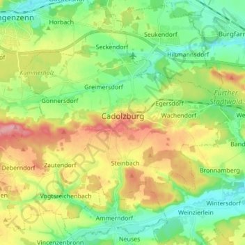
Name: Cadolzburg topographic map, elevation, terrain.
Location: Cadolzburg, Landkreis Fürth, Bayern, 90556, Deutschland (49.41719 10.77882 49.49612 10.91603)
Average elevation: 346 m
Minimum elevation: 300 m
Maximum elevation: 420 m
Make a donation
Gear up for your next adventure:
As an Amazon Associate, this site earns from qualifying purchases at no extra cost to you.
Other topographic maps
Click on a map to view its topography, its elevation and its terrain.
Make a donation
Gear up for your next adventure:
As an Amazon Associate, this site earns from qualifying purchases at no extra cost to you.
Make a donation
Gear up for your next adventure:
As an Amazon Associate, this site earns from qualifying purchases at no extra cost to you.
Rehdorf
Deutschland > Bayern > Landkreis Fürth > Oberasbach
Durch das Dorf fließt der Kreuzbach (im Unterlauf Asbach genannt), ein linker Zufluss der Rednitz. Der Ort ist von Acker- und Grünland mit vereinzeltem Baumbestand umgeben. 1 km südlich befindet sich die Wolfshöhe (363 m ü. NHN). Eine Gemeindeverbindungsstraße führt nach Oberasbach (1 km nordöstlich)…
Average elevation: 339 m
Weiherhof
Deutschland > Bayern > Landkreis Fürth > Zirndorf
Das Dorf liegt am Banderbach, einem linken Zufluss der Bibert, am Cadolzburger Höhenzug. Im Westen grenzt der Zirndorfer Stadtwald an, im Norden und Osten der Fürther Stadtwald. Gemeindeverbindungsstraßen führen nach Oberfürberg (1 km nördlich), nach Zirndorf (2,8 km südöstlich), zur Kreisstraße FÜ…
Average elevation: 339 m
Make a donation
Gear up for your next adventure:
As an Amazon Associate, this site earns from qualifying purchases at no extra cost to you.
Hardhof
Deutschland > Bayern > Landkreis Fürth > Langenzenn > Kirchfembach > Hardhof
Average elevation: 349 m
Make a donation
Gear up for your next adventure:
As an Amazon Associate, this site earns from qualifying purchases at no extra cost to you.