
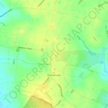
Themelthorpe topographic map
Interactive map
Click on the map to display elevation.
About this map
Name: Themelthorpe topographic map, elevation, terrain.
Location: Themelthorpe, Broadland, Norfolk, England, United Kingdom (52.76759 1.03857 52.79017 1.07072)
Average elevation: 50 m
Minimum elevation: 36 m
Maximum elevation: 60 m
Other topographic maps
Click on a map to view its topography, its elevation and its terrain.
Upgate
United Kingdom > England > Norfolk > Broadland > Swannington
Upgate, Swannington, Broadland, Norfolk, England, NR9 5AH, United Kingdom
Average elevation: 31 m
Haveringland
United Kingdom > England > Norfolk > Broadland
Haveringland, Broadland, Norfolk, England, United Kingdom
Average elevation: 35 m
Whitwell
United Kingdom > England > Norfolk > Broadland
Whitwell, Broadland, Norfolk, England, NR10 4RD, United Kingdom
Average elevation: 34 m
North Burlingham
United Kingdom > England > Norfolk > Broadland
North Burlingham, Broadland, Norfolk, England, NR13 4TA, United Kingdom
Average elevation: 21 m
Silvergate
United Kingdom > England > Norfolk > Broadland > Blickling
Silvergate, Blickling, Broadland, Norfolk, England, NR11 6NN, United Kingdom
Average elevation: 34 m
Hellesdon
United Kingdom > England > Norfolk > Broadland
Hellesdon, Broadland, Norfolk, England, United Kingdom
Average elevation: 27 m
Cantley
United Kingdom > England > Norfolk > Broadland
Cantley, Broadland, Norfolk, England, NR13 3SR, United Kingdom
Average elevation: 6 m
Haveringland Lake
United Kingdom > England > Norfolk > Broadland > Haveringland
Haveringland Lake, Haveringland, Broadland, Norfolk, England, United Kingdom
Average elevation: 39 m
Great Witchingham Village Hall Park
United Kingdom > England > Norfolk > Broadland > Lenwade > Great Witchingham
Great Witchingham Village Hall Park, Great Witchingham, Lenwade, Broadland, Norfolk, England, United Kingdom
Average elevation: 26 m
Witton
United Kingdom > England > Norfolk > Broadland
Witton, Broadland, Norfolk, England, NR13 5DN, United Kingdom
Average elevation: 18 m
Hainford
United Kingdom > England > Norfolk > Broadland
Hainford, Broadland, Norfolk, England, United Kingdom
Average elevation: 21 m
Tunstall
United Kingdom > England > Norfolk > Broadland > Halvergate
Tunstall, Halvergate, Broadland, Norfolk, England, NR13 3FD, United Kingdom
Average elevation: 5 m
Weston Longville
United Kingdom > England > Norfolk > Broadland
Weston Longville, Broadland, Norfolk, England, United Kingdom
Average elevation: 35 m
Limpenhoe
United Kingdom > England > Norfolk > Broadland
Limpenhoe, Broadland, Norfolk, England, NR13 3LQ, United Kingdom
Average elevation: 7 m
Great Plumstead
United Kingdom > England > Norfolk > Broadland
Great Plumstead, Broadland, Norfolk, England, NR13 5ER, United Kingdom
Average elevation: 22 m
Frettenham
United Kingdom > England > Norfolk > Broadland
Frettenham, Broadland, Norfolk, England, United Kingdom
Average elevation: 16 m
Morton
United Kingdom > England > Norfolk > Broadland
Morton, Broadland, Norfolk, England, NR9 5SP, United Kingdom
Average elevation: 29 m
Swannington
United Kingdom > England > Norfolk > Broadland
Swannington, Broadland, Norfolk, England, United Kingdom
Average elevation: 29 m
Buxton Heath
United Kingdom > England > Norfolk > Broadland
Buxton Heath, Hevingham, Broadland, Norfolk, England, United Kingdom
Average elevation: 35 m
Reedham
United Kingdom > England > Norfolk > Broadland
Reedham, Broadland, Norfolk, England, United Kingdom
Average elevation: 4 m
Brundall
United Kingdom > England > Norfolk > Broadland
Brundall, Broadland, Norfolk, England, United Kingdom
Average elevation: 11 m
Horsford
United Kingdom > England > Norfolk > Broadland
Horsford, Broadland, Norfolk, England, United Kingdom
Average elevation: 29 m
South Walsham
United Kingdom > England > Norfolk > Broadland
South Walsham, Broadland, Norfolk, England, United Kingdom
Average elevation: 11 m
New Rackheath
United Kingdom > England > Norfolk > Broadland > New Rackheath
New Rackheath, Broadland, Norfolk, East of England, England, NR13 6QW, United Kingdom
Average elevation: 28 m
Horstead
United Kingdom > England > Norfolk > Broadland > Coltishall
Horstead, Frettenham Road, Horstead with Stanninghall, Coltishall, Broadland, Norfolk, East of England, England, NR12 7LA, United Kingdom
Average elevation: 14 m
Spixworth
United Kingdom > England > Norfolk > Broadland
Spixworth, Broadland, Norfolk, England, United Kingdom
Average elevation: 21 m
Beighton
United Kingdom > England > Norfolk > Broadland
Beighton, Broadland, Norfolk, England, United Kingdom
Average elevation: 17 m
Strumpshaw
United Kingdom > England > Norfolk > Broadland
Strumpshaw, Lingwood, Broadland, Norfolk, England, United Kingdom
Average elevation: 11 m
Aylsham
United Kingdom > England > Norfolk > Broadland
Aylsham, Broadland, Norfolk, England, United Kingdom
Average elevation: 25 m
Coltishall
United Kingdom > England > Norfolk > Broadland
Coltishall, Broadland, Norfolk, England, United Kingdom
Average elevation: 13 m
Thorpe Marriott
United Kingdom > England > Norfolk > Broadland
Thorpe Marriott, Broadland, Norfolk, England, NR8 6UR, United Kingdom
Average elevation: 29 m
Rackheath
United Kingdom > England > Norfolk > Broadland
Rackheath, Broadland, Norfolk, England, United Kingdom
Average elevation: 26 m
Reepham
United Kingdom > England > Norfolk > Broadland
Reepham, Broadland, Norfolk, England, United Kingdom
Average elevation: 41 m
Halvergate
United Kingdom > England > Norfolk > Broadland
Halvergate, Broadland, Norfolk, England, United Kingdom
Average elevation: 6 m
Salhouse
United Kingdom > England > Norfolk > Broadland
Salhouse, Broadland, Norfolk, England, United Kingdom
Average elevation: 19 m
Woodbastwick
United Kingdom > England > Norfolk > Broadland
Woodbastwick, Broadland, Norfolk, England, United Kingdom
Average elevation: 9 m
Blofield
United Kingdom > England > Norfolk > Broadland
Blofield, Broadland, Norfolk, England, United Kingdom
Average elevation: 20 m
Cawston
United Kingdom > England > Norfolk > Broadland
Cawston, Broadland, Norfolk, East of England, England, United Kingdom
Average elevation: 42 m
Hevingham
United Kingdom > England > Norfolk > Broadland
Hevingham, Broadland, Norfolk, England, United Kingdom
Average elevation: 29 m
Reedham
United Kingdom > England > Norfolk > Broadland
Reedham, Broadland, Norfolk, England, NR13 3AR, United Kingdom
Average elevation: 3 m
Blofield Heath
United Kingdom > England > Norfolk > Broadland > Blofield Heath
Blofield Heath, Broadland, Norfolk, East of England, England, NR13 4QW, United Kingdom
Average elevation: 20 m
Wroxham
United Kingdom > England > Norfolk > Broadland
Wroxham, Broadland, Norfolk, England, United Kingdom
Average elevation: 10 m
Little Plumstead
United Kingdom > England > Norfolk > Broadland
Little Plumstead, Broadland, Norfolk, England, NR13 5HZ, United Kingdom
Average elevation: 23 m
Lamas
United Kingdom > England > Norfolk > Broadland
Lamas, Broadland, Norfolk, England, NR10 5JH, United Kingdom
Average elevation: 13 m
Hemblington
United Kingdom > England > Norfolk > Broadland > Hemblington
Hemblington, Broadland, Norfolk, East of England, England, United Kingdom
Average elevation: 20 m